
Haz una donación
Mapa topográfico Ernakulam
Haga clic en el mapa para ver la altitud.
Haz una donación
Ernakulam
The Ernakulam district covers an area of 2,408 km2 (930 sq mi) on the Western Coastal Plains of India. It is surrounded by the Thrissur District to the north, the Idukki District and Coimbatore District to the east, Alappuzha and Kottayam to the south and the Laccadive Sea to the west. The district is divided geographically into highland, midland, and coastal area. The altitude of the highlands is about 300 m (980 ft). The Periyar River, Kerala's longest, flows through all the taluks except Muvattupuzha. The Muvattupuzha River and a branch of the Chalakkudy River also flow through the district. The average yearly rainfall in the district is 3,432 mm (135.1 in). The district has a moderate climate and mostly falls within the Malabar Coast moist forests ecoregion, while the highlands are part of the South Western Ghats moist deciduous forests ecoregion.Some parts of the Idamalayar Reserve Forest and Mankulam Forest Division have Sholas but these parts are inaccessible by road. The Idamalayar Reserve Forest, and Edamalakkudy. Many types of sand, soil, and rocks are abundant here. Cochin International Airport is located in the northern part of the district at Nedumbassery, Kochi.
Haz una donación
Acerca de este mapa
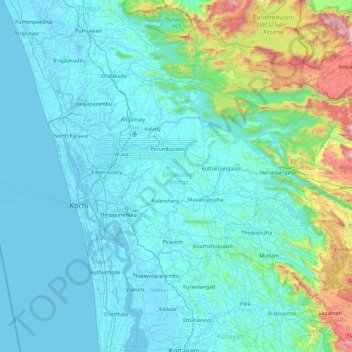
Nombre: Mapa topográfico Ernakulam, altitud, relieve.
Lugar: Ernakulam, Kerala, India (9.77369 76.16284 10.30322 76.91957)
Altitud media: 133 m
Altitud mínima: -4 m
Altitud máxima: 1,393 m
Haz una donación
Otros mapas topográficos
Haga clic en un mapa para ver su topografía, su altitud y su relieve.
Western Ghats
The range starts near south of the Tapti river and runs approximately 1,600 km (990 mi) through the states of Gujarat, Maharashtra, Karnataka, Goa, Kerala and Tamil Nadu ending at Marunthuvazh Malai, Swamithope near the southern tip of India. These hills cover 160,000 km2 (62,000 sq mi) and form the catchment…
Altitud media: 2,225 m
Thiruvananthapuram
India > Kerala > Thiruvananthapuram
Thiruvananthapuram is built on seven hills by the seashore and is at 8°30′N 76°54′E / 8.5°N 76.9°E / 8.5; 76.9 on the west coast, near the southern tip of mainland India. The city is on the west coast of India and is bounded by the Laccadive Sea to its west and the Western Ghats to its east.…
Altitud media: 33 m
Kollam
Cosmas Indicopleustes, a Greek Nestorian sailor, in his book the Christian Topography who visited the Malabar Coast in 550, mentions an enclave of Christian believers in Male (Malabar Coast). He writes, "In the island of Tabropane (Ceylon), there is a church of Christians, and clerics and faithful. Likewise at…
Altitud media: 11 m
Haz una donación
Haz una donación
Anamudi
Anamudi ("Elephant head") is a mountain located in Ernakulam district and Idukki district of the Indian state of Kerala. With an elevation of 2,695 metres (8,842 ft) and a topographic prominence of 2,479 metres (8,133 ft), it is the highest peak in the Western Ghats and in South India.
Altitud media: 2,209 m
Haz una donación
Haz una donación
Haz una donación
Pattithanam
Pattithanam is a village near Ettumanoor in the Kottayam District of Kerala, India. The name 'Pattithanam' is believed to be given by the Portuguese traders, who were looking for an ideal spot to build a church (St.Boniface Church). Pattithanam(Pattia Sthanam) means ideal place in Malayalam. Pattithanam…
Altitud media: 38 m
Haz una donación
Kalpetta
Kalpetta is a city and town and Wayanad Grade 2 municipality in the Wayanad district of the Indian state of Kerala. Kalpetta is the headquarters of the Wayanad district, as well as the headquarters of Vythiri taluk. It is surrounded by dense coffee and tea plantations and mountains. It lies on the…
Altitud media: 809 m
Haz una donación
Haz una donación
Haz una donación
Mannarkkad
Mannarkkad is located at 10°59′N 76°28′E / 10.98°N 76.47°E / 10.98; 76.47. It has an average elevation of 76 m (249 ft). Mannarkkad is located 36 km north-west of district headquarters Palakkad, along National Highway 966 and 100 km north west of Kozhikode. Mannarkkad is located in the…
Altitud media: 80 m
Haz una donación
Haz una donación
Haz una donación
Haz una donación
Haz una donación
Haz una donación
Thrissur
Thrissur is the headquarters of Thrissur district, in the center of the Indian state of Kerala. The city is 75 km north-east of Kochi, 133 km south-west of Coimbatore, 124 km south-east of Kozhikode and 151 km north of Changanacherry. The city is located in a hillock called Thekkinkadu Maidan which is the…
Altitud media: 36 m
Haz una donación
Haz una donación
Tirurangadi
India > Kerala > Tirurangadi
Tirurangadi is located at 11°03′N 75°56′E / 11.05°N 75.93°E / 11.05; 75.93. It has an average elevation of 10 m (33 ft).
Altitud media: 24 m
Haz una donación
Haz una donación
Haz una donación
Haz una donación
Kattappana
The average elevation of Kattappana Municipality is 950 m above sea level.
Altitud media: 950 m
Haz una donación
Nilambur
The 2,554 m (8,379 ft) m high Mukurthi peak, which is situated in the border of Nilambur Taluk and Ooty Taluk, and is also the fifth-highest peak in South India as well as the third-highest in Kerala after Anamudi (2,696 m [8,845 ft]) and Meesapulimala (2,651 m [8,698 ft]), is the highest point of elevation in…
Altitud media: 33 m
Haz una donación
Haz una donación
Elappara
Elappara is a town in Idukki district in the southwestern Indian state of Kerala. It is one of the panchayaths in Peerumedu taluk. The area is marked by a cool climate as the region is situated at an elevation of over 1,000 m (3,300 ft) above sea level. Elappara is famous for its vast tea plantations.
Altitud media: 1,049 m
Haz una donación