
Mapa topográfico Elappara
Haga clic en el mapa para ver la altitud.
Elappara
Elappara is a town in Idukki district in the southwestern Indian state of Kerala. It is one of the panchayaths in Peerumedu taluk. The area is marked by a cool climate as the region is situated at an elevation of over 1,000 m (3,300 ft) above sea level. Elappara is famous for its vast tea plantations.
Acerca de este mapa
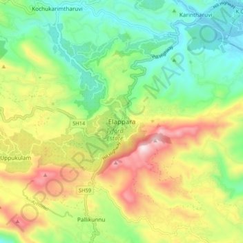
Nombre: Mapa topográfico Elappara, altitud, relieve.
Lugar: Elappara, Peerumade, Idukki, Kerala, 685501, India (9.59062 76.93847 9.67062 77.01847)
Altitud media: 1,049 m
Altitud mínima: 762 m
Altitud máxima: 1,508 m
Otros mapas topográficos
Haga clic en un mapa para ver su topografía, su altitud y su relieve.
Periyar National Park Tiger Reserve
Periyar National Park lies in the middle of a mountainous area of the Cardamom Hills. In the north : The boundary commences from the point nearest to the Medaganam in the interstate boundary up to Vellimalai. and the east Thence the boundary follows the inter-state boundary from Vellimalai to Kallimalai Peak…
Altitud media: 929 m