
Mapa topográfico Pattithanam
Haga clic en el mapa para ver la altitud.
Pattithanam
Pattithanam is a village near Ettumanoor in the Kottayam District of Kerala, India. The name 'Pattithanam' is believed to be given by the Portuguese traders, who were looking for an ideal spot to build a church (St.Boniface Church). Pattithanam(Pattia Sthanam) means ideal place in Malayalam. Pattithanam village is the point of highest altitude on Main Central Road (MC Road). The early settlers in Pattithanam played a major role in establishing the educational and religious institutions in this area. During the early days, the nearest market was Athirampuzha and the agricultural produce was taken by bullock cart and head load from Pattithanm on market days. Pattithanam village is within Meenachil and Kottayam taluks of Kottayam District of Kerala.
Acerca de este mapa
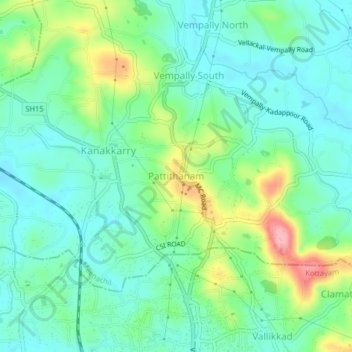
Nombre: Mapa topográfico Pattithanam, altitud, relieve.
Lugar: Pattithanam, Meenachil, Kottayam, Kerala, 686631, India (9.67936 76.53563 9.71936 76.57563)
Altitud media: 38 m
Altitud mínima: 3 m
Altitud máxima: 123 m
Otros mapas topográficos
Haga clic en un mapa para ver su topografía, su altitud y su relieve.
Cherppungal Kulam Cheripurathu Padasekaram Karikombu
India > Kerala > Meenachil > Cherpunkal
Altitud media: 29 m