
Haz una donación
Mapa topográfico Newcastle-under-Lyme
Haga clic en el mapa para ver la altitud.
Haz una donación
Acerca de este mapa
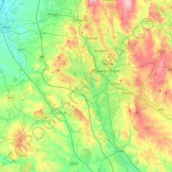
Nombre: Mapa topográfico Newcastle-under-Lyme, altitud, relieve.
Lugar: Newcastle-under-Lyme, Staffordshire, England, United Kingdom (52.87398 -2.47079 53.11581 -2.18109)
Altitud media: 149 m
Altitud mínima: 44 m
Altitud máxima: 330 m
Haz una donación
Otros mapas topográficos
Haga clic en un mapa para ver su topografía, su altitud y su relieve.
Red Bull
United Kingdom > England > Staffordshire > Newcastle-under-Lyme > Loggerheads
Altitud media: 110 m
Burton upon Trent
United Kingdom > England > Staffordshire > East Staffordshire
Burton is about 109 miles (175 km) north west of London, about 30 miles north east of Birmingham, the UK's second largest city and about 23 miles east of the county town Stafford. It is at the easternmost border of the county of Staffordshire with Derbyshire, its suburbs and the course of the River Trent…
Altitud media: 69 m
Castle Ring
United Kingdom > England > Staffordshire > Cannock Chase > Cannock Wood
It is the highest point on The Chase with an elevation of 242 metres (794 ft).
Altitud media: 191 m
Haz una donación
Flash
United Kingdom > England > Staffordshire > Staffordshire Moorlands
Flash is a village in the Staffordshire Moorlands and the Peak District National Park, England. At 1,519 feet (463 m) above sea level, it is the highest village in the United Kingdom (some sources claim a height of 1,531 feet (467 m) for Wanlockhead in Scotland, but a survey in 2019 showed that there are no…
Altitud media: 412 m
Haz una donación
Haz una donación
Baggeridge Country Park
United Kingdom > England > Staffordshire > South Staffordshire
Altitud media: 146 m
Dimmingsdale Valley
United Kingdom > England > Staffordshire > Staffordshire Moorlands > Alton
Altitud media: 177 m
Haz una donación
Weston Park
United Kingdom > England > Staffordshire > South Staffordshire > Weston under Lizard
Altitud media: 113 m
Haz una donación
Stepping Stones
United Kingdom > England > Staffordshire > Staffordshire Moorlands
Altitud media: 224 m
Haz una donación
Bottomhouse
United Kingdom > England > Staffordshire > Staffordshire Moorlands > Ipstones
Altitud media: 312 m
Haz una donación
Apedale
United Kingdom > England > Staffordshire > Newcastle-under-Lyme > Chesterton
Altitud media: 168 m
Levedale
United Kingdom > England > Staffordshire > South Staffordshire > Penkridge
Altitud media: 98 m
Roughcote
United Kingdom > England > Staffordshire > Staffordshire Moorlands > Caverswall
Altitud media: 217 m
Haz una donación
Blackshaw Moor
United Kingdom > England > Staffordshire > Staffordshire Moorlands > Thorncliffe
Altitud media: 282 m
Haz una donación
Haz una donación
Haz una donación
Talke Pits
United Kingdom > England > Staffordshire > Newcastle-under-Lyme > Talke
Altitud media: 179 m
Haz una donación
Blore
United Kingdom > England > Staffordshire > Newcastle-under-Lyme > Loggerheads
Altitud media: 137 m
Six Ashes
United Kingdom > England > Staffordshire > South Staffordshire > Bobbington
Altitud media: 125 m
Haz una donación
Ashley Dale
United Kingdom > England > Staffordshire > Newcastle-under-Lyme > Loggerheads
Altitud media: 172 m
Draycott Cross
United Kingdom > England > Staffordshire > Staffordshire Moorlands > Boundary
Altitud media: 183 m
Haz una donación
Marchington Woodlands
United Kingdom > England > Staffordshire > East Staffordshire
Altitud media: 120 m
Barhill
United Kingdom > England > Staffordshire > Newcastle-under-Lyme > Madeley
Altitud media: 122 m
The Moss
United Kingdom > England > Staffordshire > Newcastle-under-Lyme > Madeley
Altitud media: 122 m
Haz una donación
Haz una donación
Ladderedge Country Park
United Kingdom > England > Staffordshire > Staffordshire Moorlands > Leek
Altitud media: 176 m
Weston under Lizard
United Kingdom > England > Staffordshire > South Staffordshire
Altitud media: 111 m
Haz una donación
CBeebies Land
United Kingdom > England > Staffordshire > Staffordshire Moorlands > Farley
Altitud media: 167 m
Haz una donación
College Gardens
United Kingdom > England > Staffordshire > Newcastle-under-Lyme > Madeley
Altitud media: 123 m
Tutbury Castle
United Kingdom > England > Staffordshire > East Staffordshire > Tutbury
Altitud media: 66 m
Haz una donación
Stubwood
United Kingdom > England > Staffordshire > East Staffordshire > Denstone
Altitud media: 113 m
Birch Cross
United Kingdom > England > Staffordshire > East Staffordshire > Marchington
Altitud media: 92 m
Haz una donación
Wain Lea
United Kingdom > England > Staffordshire > Newcastle-under-Lyme > Harriseahead
Altitud media: 207 m
Haz una donación
Newcastle-under-Lyme
United Kingdom > England > Staffordshire > Newcastle-under-Lyme
Altitud media: 147 m
Bignall End
United Kingdom > England > Staffordshire > Newcastle-under-Lyme > Audley
Altitud media: 150 m
Haz una donación
Haz una donación
Horton
United Kingdom > England > Staffordshire > Staffordshire Moorlands > Gratton
Altitud media: 199 m
Wood Lane
United Kingdom > England > Staffordshire > Newcastle-under-Lyme > Bignall Hill
Altitud media: 168 m
Haz una donación
Rushton Spencer
United Kingdom > England > Staffordshire > Staffordshire Moorlands
Altitud media: 204 m
Calf Heath
United Kingdom > England > Staffordshire > South Staffordshire > Hatherton Junction
Altitud media: 113 m
Chasewater
United Kingdom > England > Staffordshire > Lichfield > Burntwood > Chasetown
Altitud media: 155 m
Haz una donación