
Gracias por apoyar a este sitio ❤️
Haz una donación
Haz una donación
Mapa topográfico Norton Canes
Haga clic en el mapa para ver la altitud.
Gracias por apoyar a este sitio ❤️
Haz una donación
Haz una donación
Acerca de este mapa
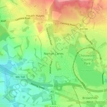
Nombre: Mapa topográfico Norton Canes, altitud, relieve.
Altitud media: 158 m
Altitud mínima: 120 m
Altitud máxima: 212 m
Gracias por apoyar a este sitio ❤️
Haz una donación
Haz una donación
Otros mapas topográficos
Haga clic en un mapa para ver su topografía, su altitud y su relieve.
Cannock Chase National Landscape
United Kingdom > England > Staffordshire > Cannock Chase
Altitud media: 134 m
Castle Ring
United Kingdom > England > Staffordshire > Cannock Chase > Cannock Wood
It is the highest point on The Chase with an elevation of 242 metres (794 ft).
Altitud media: 191 m
Gracias por apoyar a este sitio ❤️
Haz una donación
Haz una donación
Norton Canes
United Kingdom > England > Staffordshire > Cannock Chase > Norton Canes
Altitud media: 149 m