
Mapa topográfico Flash
Haga clic en el mapa para ver la altitud.
Flash
Flash is a village in the Staffordshire Moorlands and the Peak District National Park, England. At 1,519 feet (463 m) above sea level, it is the highest village in the United Kingdom (some sources claim a height of 1,531 feet (467 m) for Wanlockhead in Scotland, but a survey in 2019 showed that there are no buildings in Wanlockhead at that elevation). Flash was an early centre for Wesleyanism.
Acerca de este mapa
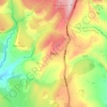
Nombre: Mapa topográfico Flash, altitud, relieve.
Altitud media: 412 m
Altitud mínima: 285 m
Altitud máxima: 548 m
Otros mapas topográficos
Haga clic en un mapa para ver su topografía, su altitud y su relieve.
Rudyard Lake
United Kingdom > England > Staffordshire > Staffordshire Moorlands > Rudyard > Horton
Altitud media: 205 m
Stepping Stones
United Kingdom > England > Staffordshire > Staffordshire Moorlands
Altitud media: 224 m
Biddulph Grange Country Park
United Kingdom > England > Staffordshire > Staffordshire Moorlands > Biddulph > Biddulph Moor
Altitud media: 229 m
Hales Hall Pool
United Kingdom > England > Staffordshire > Staffordshire Moorlands > Cheadle
Altitud media: 182 m
Draycott in the Moors
United Kingdom > England > Staffordshire > Staffordshire Moorlands
Altitud media: 177 m
Ladderedge Country Park
United Kingdom > England > Staffordshire > Staffordshire Moorlands > Leek
Altitud media: 176 m
Checkley
United Kingdom > England > Staffordshire > Staffordshire Moorlands > Checkley
Altitud media: 166 m
Dimmingsdale Valley
United Kingdom > England > Staffordshire > Staffordshire Moorlands > Alton
Altitud media: 177 m
Alton Castle
United Kingdom > England > Staffordshire > Staffordshire Moorlands > Alton
Altitud media: 154 m
Consall
United Kingdom > England > Staffordshire > Staffordshire Moorlands > Consall
Altitud media: 216 m
Endon Basin
United Kingdom > England > Staffordshire > Staffordshire Moorlands > Endon
Altitud media: 179 m