Geolocalizar

Mapa topográfico Pampanga

Haga clic en el mapa para ver la altitud.

Acerca de este mapa

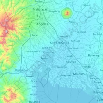
Nombre: Mapa topográfico Pampanga, altitud, relieve.

Lugar: Pampanga, Central Luzon, Philippines (14.67001 120.35851 15.27892 120.95257)

Altitud media: 122 m

Altitud mínima: -2 m

Altitud máxima: 1,551 m

Otros mapas topográficos

Haga clic en un mapa para ver su topografía, su altitud y su relieve.

Quezon City

Philippines

Founded as a pueblo by Saint Pedro Bautista in 1590, San Francisco del Monte may be considered Quezon City's oldest district. The original land area of the old town of San Francisco del Monte was approximately2.5 square kilometres (1.0 sq mi) and covered parts of what is currently known as Project 7 and 8 and…

Altitud media: 57 m

Taytay

Philippines > Marinduque > Santa Cruz

Altitud media: 51 m

Tanay

Philippines > Rizal

Altitud media: 32 m

Iligan

Philippines

Altitud media: 229 m

Daraga

Philippines > Albay

67.3% of the total municipal land area has a predominantly low elevation of up to 100 metres (330 ft). The surface terrain is generally characterized by combination of level to nearly level areas, gentle to undulating areas and undulating to rolling areas.

Altitud media: 76 m

Tagaytay

Philippines > Cavite

The southern and eastern portions of Tagaytay are covered by hills and mountains which is generally forests, pine trees and open grasslands. The city lies along Tagaytay Ridge, a ridge stretching about 32 kilometres (20 mi) from Mount Batulao in the west to Mount Sungay in the east with elevations averaging…

Altitud media: 229 m

Aurora

Philippines > Apayao

Altitud media: 83 m

Pasay

Philippines

Altitud media: 14 m

Bacolod

Philippines

Bacólod (English: Bacolod), is derived from bakólod (Old Spelling: bacólod), the Old Hiligaynon (Old Ilonggo) (Old Spelling: Ylongo and Ilongo) word for a "hill, turtle, mound, rise, hillock, down, any small eminence or elevation", since the resettlement was founded on a stony, hilly area, now the barangay…

Altitud media: 49 m

San Ignacio

Philippines > Batangas > Rosario

Altitud media: 138 m

Salangan

Philippines > Bulacan > San Miguel

Altitud media: 16 m

Pinagtung-ulan

Philippines > Batangas > San Jose

Altitud media: 348 m

Cebu City

Philippines > Cebu > Cebu City

Altitud media: 140 m

Montalban

Philippines > Rizal > Rodriguez

Rodriguez is generally very rough in topography, with 83% of its total land area composed of upland areas, hills and mountain ranges. The remaining 17% low-lying terrain and rolling lands are found at the south-western portion of the municipality, along with the northern portions of the Municipality of San…

Altitud media: 99 m

Vigan

Philippines > Ilocos Sur

Vigan is situated in a Quaternary Age sedimentary plain called the Vigan-Bantay Plain which is part of the Ilocos coastal plain. The Vigan-Bantay Plain is bounded on the east by a moderately rugged Miocene sediments consisting of interbedded sandstones and shale to very rugged Meta-volcanics and Meta sediment…

Altitud media: 63 m

Sapang Buho

Philippines > Nueva Ecija > Palayan

Altitud media: 67 m

Caloocan

Philippines > Caloocan > Caloocan

Altitud media: 19 m

Butuan

Philippines

Altitud media: 115 m

San Isidro

Philippines > Albay > Santo Domingo

Altitud media: 62 m

Valencia

Philippines > Negros Oriental > Valencia

Valencia occupies an area of 14,749 hectares (36,450 acres), 35% of which are classified as plains. The town is 65% mountainous, with elevation averaging from 200 to 500 metres (660 to 1,640 ft) above sea level, with the top of Mount Talinis at an elevation of 1,903 metres (6,243 ft) along the municipal…

Altitud media: 250 m

Samal Island

Philippines > Davao del Norte > Samal

Altitud media: 117 m

Santa Rosa

Philippines > Laguna > Santa Rosa

Altitud media: 65 m

Buhang

Philippines > Antique > Hamtic

Altitud media: 43 m

Sandingan Island

Philippines > Bohol > Canigaan

Altitud media: 14 m

Tamayo

Philippines > Marinduque > Santa Cruz

Altitud media: 20 m

Santa Ines

Philippines > Pampanga > Bacolor

Altitud media: 8 m

Polo

Philippines > Cebu > Alcantara

Altitud media: 25 m

Sinaragan

Philippines > Davao del Sur > Matanao

Altitud media: 60 m

Malolos

Philippines > Bulacan

Malolos is relatively flat of about 0.81% to a gently sloping of 2.17%. The slope of the land descends towards west, southwest to southern direction. The highest land elevation is at about 6.0 meters above sea level while the lowest is only half a meter below sea level. A network of natural waterways and…

Altitud media: 6 m

Zamboanga City

Philippines > Zamboanga Peninsula > Zamboanga City

The overall topography of the city could be described as rolling to very steep. There are some flat lands, mostly narrow strips along the east coast. The urban center is mostly flat with a gentle slope to the interior, ranging from 0 to 3%. The highest registered elevation is 1,200 metres. In terms of slope, a…

Altitud media: 83 m

Iruhin East

Philippines > Cavite > Tagaytay

Altitud media: 496 m

San Roque

Philippines > Guimaras > Buenavista

Altitud media: 77 m

Cervantes

Philippines > Ilocos Sur

Altitud media: 610 m

Buhang

Philippines > Antique > Hamtic

Altitud media: 43 m

Macaniao

Philippines > Isabela

Altitud media: 83 m

Butuanon River

Philippines > Cebu City

Altitud media: 85 m

Ditawini

Philippines > Aurora

Altitud media: 80 m

Alacan

Philippines > Pangasinan > San Fabian

Altitud media: 21 m

Mount Balungao

Philippines > Pangasinan > Balungao

Altitud media: 115 m

Culat

Philippines > Aurora

Altitud media: 67 m

San Pablo

Philippines > Laguna > San Pablo

Altitud media: 220 m

Cabanatuan

Philippines > Nueva Ecija

Altitud media: 47 m

San Juan

Philippines

"San Juan" is a contraction of the city's traditional name of "San Juan del Monte" (lit. 'Saint John of the Mountain'). As with numerous other places in the Philippines, the name combines a patron saint and a toponym; in this case Saint John the Baptist with the locale's hilly terrain and relatively higher…

Altitud media: 35 m

Sorsogon City

Philippines > Sorsogon

Sorsogon City covers a land area of 31,292 hectares (120.82 sq mi). It is at the southernmost tip of the Bicol Peninsula and of Luzon Island. The city is bounded by Castilla in the west, Manito in the northwest, Albay Gulf in the north, Prieto Diaz in the east, Gubat in the southeast, Casiguran in the…

Altitud media: 89 m

Antipolo

Philippines > Rizal

Its higher elevation than that of Metro Manila affords it a scenic view of the metropolis, especially at night. Its locally grown mangoes and cashews are popular among tourists, as well as suman – a local delicacy made out of glutinous rice. The Hinulugang Taktak National Park, which was once a popular…

Altitud media: 125 m

Mandaluyong

Philippines

Another claims that the Spaniards named the place based on the report of a navigator named Acapulco, who saw the rolling hills frequently being lashed at by daluyong (“big waves from the sea”). This seems to confirm traditional pre-Hispanic stories that giant waves from the sea would meet the adjoining…

Altitud media: 33 m

San Fernando

Philippines > Pampanga

Altitud media: 24 m

Burgos

Philippines > Surigao del Sur > Cortes

Altitud media: 55 m

Bayog

Philippines > Zamboanga del Sur

The town is partly situated in the Sibougey Valley watered by the Sibuguey River, Dipili River, and Depore River. 75% of the land lies on rugged terrain with elevation up to 300 metres (980 ft).

Altitud media: 137 m

Sharp Peak

Philippines > Sorsogon

Altitud media: 810 m

Bongbong

Philippines > Negros Oriental > Valencia

Altitud media: 341 m

Talim Island

Philippines > Rizal > Kinaboogan

Altitud media: 13 m

Ormoc

Philippines > Leyte > Ormoc

Altitud media: 204 m

Mandaue

Philippines

It is one of the two (the other one being the municipality of Consolacion) local government units located within the mainland Metro Cebu where the elevation of land is less than 100 m (330 ft).

Altitud media: 109 m

San Fernando

Philippines > La Union

Altitud media: 81 m

Urdaneta

Philippines > Pangasinan

Altitud media: 42 m

Lapu-Lapu

Philippines

Altitud media: 93 m

Baguio

Philippines

In 1903, Filipinos, Japanese and Chinese workers were hired to build Kennon Road, the first road directly connecting Baguio with the lowlands of La Union and Pangasinan. Before this, the only road to Benguet was Naguilian Road, and it was largely a horse trail at higher elevations. Camp John Hay was…

Altitud media: 881 m

Hambabauran

Philippines > Bohol > Ubay

Altitud media: 22 m

Butong

Philippines > Bukidnon > Quezon

Altitud media: 383 m

Rabon

Philippines > Pangasinan

Altitud media: 22 m

Buenavista

Philippines > Cagayan > Claveria

Altitud media: 48 m

Osmeña Peak

Philippines > Cebu > Dalaguete

Altitud media: 870 m

Caliraya

Philippines > Laguna > Lumban

Altitud media: 264 m

Kandungaw Peak

Philippines > Cebu > Maloray

Altitud media: 744 m

Amadeo

Philippines > Cavite > Amadeo

Altitud media: 422 m

Tolentino West

Philippines > Cavite > Tagaytay

Altitud media: 522 m

La Paz

Philippines > Tarlac > Bamban

Altitud media: 74 m

Dominorog

Philippines > Bukidnon > Talakag

Altitud media: 1,194 m

Guinaang

Philippines > Mountain Province

Altitud media: 1,301 m

Gagalot

Philippines > Laguna > Majayjay

Altitud media: 412 m

Cabugao

Philippines > Palawan > Coron

Altitud media: 93 m

Maydolong

Philippines > Eastern Samar

Altitud media: 14 m

Concepcion Banahaw

Philippines > Quezon > Sariaya

Altitud media: 357 m

Tuba

Philippines > Benguet

Tuba's topography is generally characterized by irregular rugged terrain and steep slopes with several mountain peaks rising from the table land itself. Mount Santo Tomas, the highest peak in the municipality soars to 2,252 metres (7,388 ft) above sea level.

Altitud media: 1,242 m

Mount Apo

Philippines > Davao del Sur > Bansalan

Mount Apo is the highest mountain peak in the Philippines, with an elevation of 2,954 meters (9,692 ft) above sea level. A large solfataric, dormant stratovolcano, it is part of the Apo-Talomo Mountain Range of Mindanao island. Apo is situated on the tripartite border of Davao City, Davao del Sur, and…

Altitud media: 2,416 m

Rizal Park

Philippines > Romblon > Banton > Toctoc > Apayang

Altitud media: 78 m

Siruma

Philippines > Camarines Sur

Altitud media: 9 m

Cabaracan

Philippines > Leyte > Julita > Arado

Altitud media: 21 m

Abungan

Philippines > Aurora > Dingalan

Altitud media: 45 m

Linao Norte

Philippines > Cagayan > Tuguegarao

Altitud media: 21 m

Supang

Philippines > Guimaras > Buenavista

Altitud media: 72 m

Baguingey

Philippines > Benguet > Itogon

Altitud media: 914 m

Elian

Philippines > Davao City > Marilog Proper

Altitud media: 699 m

Dalaguete

Philippines > Cebu

Altitud media: 70 m