
Mapa topográfico Hoshiarpur
Haga clic en el mapa para ver la altitud.
Acerca de este mapa
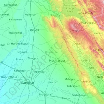
Nombre: Mapa topográfico Hoshiarpur, altitud, relieve.
Lugar: Hoshiarpur, Punjab, India (31.13274 75.47139 32.08574 76.34936)
Altitud media: 358 m
Altitud mínima: 216 m
Altitud máxima: 1,119 m
Otros mapas topográficos
Haga clic en un mapa para ver su topografía, su altitud y su relieve.
Patiala
India > Punjab > Patiala Tahsil
Patiala is located at 30°19′N 76°24′E / 30.32°N 76.40°E / 30.32; 76.40. It has an average elevation of 250 metres (820 feet). During the short existence of PEPSU, Patiala served as its capital city.
Altitud media: 255 m
Bathinda
India > Punjab > Bathinda Tahsil
Bathinda is in the northwestern region of India and is a part of the Indo-Gangetic alluvial plains. The exact cartographic co-ordinates of Bathinda are 30°12′N 74°57′E / 30.20°N 74.95°E / 30.20; 74.95. It has an average elevation of 201 metres (660 ft).
Altitud media: 208 m
Dasuya
India > Punjab > Dasua Tahsil
Dasuya is located in Hoshiarpur district of Punjab state in India. at 31°49′N 75°40′E / 31.82°N 75.66°E / 31.82; 75.66. It has an average elevation of 239 metres (784 ft) from sea level.
Altitud media: 254 m
Nabha
India > Punjab > Nabha Tahsil
Nabha is located at 30°22′N 76°09′E / 30.37°N 76.15°E / 30.37; 76.15. It has an average elevation of 246 metres (807 feet).
Altitud media: 251 m
Faridkot
India > Punjab > Faridkot Tahsil
The average elevation is 196 metres (643 ft). The town is located on the Punjab Plains, which in a macro regional context forms a part of greater Satluj Ganga plain. It is a low-lying flat area. The surface of the district is depositional plain which was formed by alleviation by the rivers flowing in these…
Altitud media: 204 m
Amritsar
India > Punjab > Amritsar I Tahsil
Amritsar is located at 31°38′N 74°52′E / 31.63°N 74.87°E / 31.63; 74.87 with an average elevation of 234 metres (768 ft) in the Majha region of the state of Punjab in North India and lies about 15 miles (24 km) east of the border with Pakistan. Administrative towns includes Ajnala, Attari,…
Altitud media: 231 m
Ludhiana
India > Punjab > Ludhiana (West) Tahsil
Ludhiana is located at 30°54′N 75°51′E / 30.9°N 75.85°E / 30.9; 75.85. It has an average elevation of 244 metres (801 ft). Ludhiana City, to its residents, consists of the Old City and the New City. The new city primarily consists of the Civil Lines area which was historically known as the…
Altitud media: 247 m