
Haz una donación
Mapa topográfico Crich CP
Haga clic en el mapa para ver la altitud.
Haz una donación
Crich CP
The memorial tower ('Crich Stand') was completed in 1923 as a memorial to the 11,409 soldiers from the Sherwood Foresters Regiment who died in World War I, a dedication that was later extended to include World War II. It was built on an limestone outcrop above the village, at an altitude of 1,000 feet (300 m) above sea level. The location is symbolic because it is widely visible across, and gives views of, both of the two counties from which the regiment was raised (Nottinghamshire and Derbyshire). It is the destination of an annual pilgrimage on the first Sunday in July.
Haz una donación
Acerca de este mapa
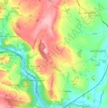
Nombre: Mapa topográfico Crich CP, altitud, relieve.
Altitud media: 159 m
Altitud mínima: 67 m
Altitud máxima: 278 m
Haz una donación
Otros mapas topográficos
Haga clic en un mapa para ver su topografía, su altitud y su relieve.
Haz una donación
Heanor
United Kingdom > England > Derbyshire > Amber Valley
Samuel Lewis's A Topographical Dictionary of England, published in 1848, states that Heanor parish "abounds with coal and ironstone, both worked extensively, the collieries alone affording employment to more than 2000 persons. The town is pleasantly situated upon an eminence, on the road from Derby to…
Altitud media: 102 m
Haz una donación
Haz una donación
Haz una donación
Nottingham Canal
United Kingdom > England > Derbyshire > Amber Valley > Langley Mill
Altitud media: 77 m
Haz una donación
Alfreton Park
United Kingdom > England > Derbyshire > Amber Valley > Alfreton CP > Oakerthorpe
Altitud media: 116 m
Haz una donación
Upper Hartshay
United Kingdom > England > Derbyshire > Amber Valley > Upper Hartshay
Altitud media: 119 m
Haz una donación
Farnah Green
United Kingdom > England > Derbyshire > Amber Valley > Blackbrook > Farnah Green
Altitud media: 117 m
Moscow Farm
United Kingdom > England > Derbyshire > Amber Valley > Makeney > Moscow Farm
Altitud media: 103 m
Haz una donación
Sawmills
United Kingdom > England > Derbyshire > Amber Valley > Ripley > Fritchley
Altitud media: 119 m
Heanor
United Kingdom > England > Derbyshire > Amber Valley
Samuel Lewis's A Topographical Dictionary of England, published in 1848, states that Heanor parish "abounds with coal and ironstone, both worked extensively, the collieries alone affording employment to more than 2000 persons. The town is pleasantly situated upon an eminence, on the road from Derby to…
Altitud media: 102 m
Haz una donación