
Haz una donación
Mapa topográfico Heanor
Haga clic en el mapa para ver la altitud.
Haz una donación
Heanor
Samuel Lewis's A Topographical Dictionary of England, published in 1848, states that Heanor parish "abounds with coal and ironstone, both worked extensively, the collieries alone affording employment to more than 2000 persons. The town is pleasantly situated upon an eminence, on the road from Derby to Mansfield. The principal articles of manufacture are silk and cotton goods, hosiery, and bobbinet lace, providing occupation to about 800 persons." The parish then covered 7,000 acres (2,800 ha) and was in the union of Basford and the hundred of Morleston and Litchurch, with Heanor town itself covering 1,500 acres (610 ha) with 3,058 inhabitants. The parish church, dedicated to St Mary, was "a very ancient edifice, with a lofty substantial tower, from which is an extensive view," though the dictionary noted there were also "places of worship for Baptists, Independents, Wesleyans, and Ranters".
Haz una donación
Acerca de este mapa
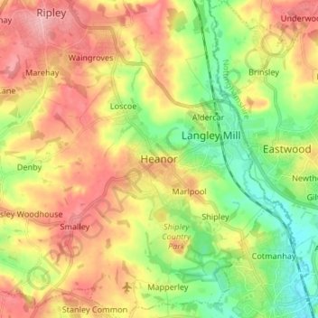
Nombre: Mapa topográfico Heanor, altitud, relieve.
Altitud media: 102 m
Altitud mínima: 45 m
Altitud máxima: 163 m
Haz una donación
Otros mapas topográficos
Haga clic en un mapa para ver su topografía, su altitud y su relieve.
Haz una donación
Crich CP
United Kingdom > England > Derbyshire > Amber Valley
The memorial tower ('Crich Stand') was completed in 1923 as a memorial to the 11,409 soldiers from the Sherwood Foresters Regiment who died in World War I, a dedication that was later extended to include World War II. It was built on an limestone outcrop above the village, at an altitude of 1,000 feet (300 m)…
Altitud media: 159 m
Haz una donación
Shipley Country Park
United Kingdom > England > Derbyshire > Amber Valley > Marlpool
Altitud media: 93 m
Haz una donación
Haz una donación
Nottingham Canal
United Kingdom > England > Derbyshire > Amber Valley > Langley Mill
Altitud media: 77 m
Haz una donación
Haz una donación
Alfreton Park
United Kingdom > England > Derbyshire > Amber Valley > Alfreton CP > Oakerthorpe
Altitud media: 116 m
Haz una donación
Dethick, Lea and Holloway CP
United Kingdom > England > Derbyshire > Amber Valley > Dethick
Altitud media: 204 m
Haz una donación
Haz una donación