
Mapa topográfico Mawlong
Mapa interactivo
Haga clic en el mapa para ver la altitud.
Acerca de este mapa
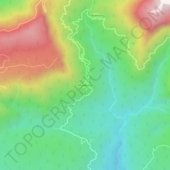
Nombre: Mapa topográfico Mawlong, altitud, relieve.
Altitud media: 470 m
Altitud mínima: 86 m
Altitud máxima: 1,129 m
Otros mapas topográficos
Haga clic en un mapa para ver su topografía, su altitud y su relieve.
Cherrapunji (Sohra)
India > Meghalaya > Shella Bholaganj > Cherrapunji (Sohra)
Cherrapunji (Sohra), Shella Bholaganj, East Khasi Hills, Meghalaya, 793108, India
Altitud media: 1,248 m