
Haz una donación
Mapa topográfico Clent
Haga clic en el mapa para ver la altitud.
Haz una donación
Clent
Because of the hilly topography of the parish the village consists of several distinct hamlets. These are Upper Clent (Clatterbach and the area around the parish church of St. Leonard), Lower Clent, Holy Cross, Adams Hill and Walton Pool. The Civil Parish of Clent also included part of the village of West Hagley, the population of which is about half that of the whole parish. On the first of April 2016, this part of the parish was transferred to the Parish of Hagley. Though in the ancient ecclesiastical parish of Clent, that area is now part of the Anglican parish of Broome. Part of the parish is an area of agricultural lowland, but to the northwest the ground rises forming the Clent Hills (now owned by the National Trust), which is a popular destination for walkers.
Haz una donación
Acerca de este mapa
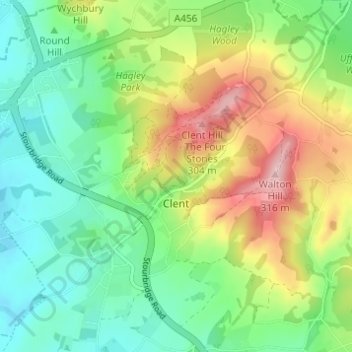
Nombre: Mapa topográfico Clent, altitud, relieve.
Lugar: Clent, Bromsgrove, Worcestershire, England, United Kingdom (52.39945 -2.13824 52.43095 -2.07696)
Altitud media: 184 m
Altitud mínima: 111 m
Altitud máxima: 312 m
Haz una donación
Otros mapas topográficos
Haga clic en un mapa para ver su topografía, su altitud y su relieve.
Haz una donación
Tanner's Green
United Kingdom > England > Worcestershire > Bromsgrove > Wythall CP
Altitud media: 158 m
Haz una donación
Major's Green
United Kingdom > England > Worcestershire > Bromsgrove > Wythall CP
Altitud media: 146 m
Haz una donación
Haz una donación