
Gracias por apoyar a este sitio ❤️
Haz una donación
Haz una donación
Mapa topográfico Hopwood
Haga clic en el mapa para ver la altitud.
Gracias por apoyar a este sitio ❤️
Haz una donación
Haz una donación
Acerca de este mapa
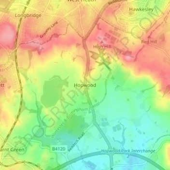
Nombre: Mapa topográfico Hopwood, altitud, relieve.
Altitud media: 160 m
Altitud mínima: 116 m
Altitud máxima: 208 m
Gracias por apoyar a este sitio ❤️
Haz una donación
Haz una donación
Otros mapas topográficos
Haga clic en un mapa para ver su topografía, su altitud y su relieve.
Gracias por apoyar a este sitio ❤️
Haz una donación
Haz una donación
Clent
United Kingdom > England > Worcestershire > Bromsgrove
Because of the hilly topography of the parish the village consists of several distinct hamlets. These are Upper Clent (Clatterbach and the area around the parish church of St. Leonard), Lower Clent, Holy Cross, Adams Hill and Walton Pool. The Civil Parish of Clent also included part of the village of West…
Altitud media: 184 m
Gracias por apoyar a este sitio ❤️
Haz una donación
Haz una donación
Gracias por apoyar a este sitio ❤️
Haz una donación
Haz una donación
Gracias por apoyar a este sitio ❤️
Haz una donación
Haz una donación
Gracias por apoyar a este sitio ❤️
Haz una donación
Haz una donación