
Mapa topográfico Chesterfield
Haga clic en el mapa para ver la altitud.
Acerca de este mapa
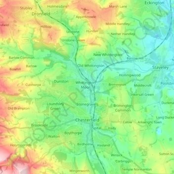
Nombre: Mapa topográfico Chesterfield, altitud, relieve.
Altitud media: 127 m
Altitud mínima: 41 m
Altitud máxima: 305 m
Otros mapas topográficos
Haga clic en un mapa para ver su topografía, su altitud y su relieve.
Heanor
United Kingdom > England > Derbyshire > Amber Valley
Samuel Lewis's A Topographical Dictionary of England, published in 1848, states that Heanor parish "abounds with coal and ironstone, both worked extensively, the collieries alone affording employment to more than 2000 persons. The town is pleasantly situated upon an eminence, on the road from Derby to…
Altitud media: 102 m
Hallam Moors
United Kingdom > England > Derbyshire > Derbyshire Dales > Hathersage
Altitud media: 368 m
Robin Wood
United Kingdom > England > Derbyshire > South Derbyshire > Stanton by Bridge CP
Altitud media: 92 m
Repton Shrubs
United Kingdom > England > Derbyshire > South Derbyshire > Repton CP
Altitud media: 110 m
Crowden Great Brook
United Kingdom > England > Derbyshire > High Peak > Tintwistle > Crowden
Altitud media: 314 m
Kinder Scout
United Kingdom > England > Derbyshire > High Peak
To the north across the Snake Pass lie the high moors of Bleaklow and Black Hill, which are of similar elevation.
Altitud media: 555 m
Slaley
United Kingdom > England > Derbyshire > Derbyshire Dales > Matlock > Bonsall CP
Altitud media: 263 m
Lightwood
United Kingdom > England > Derbyshire > North East Derbyshire > Eckington
Altitud media: 168 m
Staunton Harold Reservoir
United Kingdom > England > Derbyshire > South Derbyshire > Melbourne CP
Altitud media: 93 m
Bolehill
United Kingdom > England > Derbyshire > Derbyshire Dales > Wirksworth CP
Altitud media: 220 m
Riber Castle
United Kingdom > England > Derbyshire > Derbyshire Dales > Matlock > Starkholmes
Altitud media: 169 m
Creswell Model Village
United Kingdom > England > Derbyshire > Bolsover > Creswell Model Village
Altitud media: 101 m
Monsal Head
United Kingdom > England > Derbyshire > Derbyshire Dales > Cressbrook > Monsal Head
Altitud media: 231 m
Parsley Hay
United Kingdom > England > Derbyshire > Derbyshire Dales > Parsley Hay
Altitud media: 334 m
Barlborough Country Park
United Kingdom > England > Derbyshire > Bolsover > Clowne > Barlborough
Altitud media: 135 m
Eccles Pike
United Kingdom > England > Derbyshire > High Peak > Chapel-en-le-Frith > Whitehough > Whitehough Head
At the top of the hill is a commemorative plaque known as a topograph, showing a 360° relief of the surrounding landscape, placed by the community to mark the millennium. In early November 2011, the topograph was stolen. On 7 May 2013, it was replaced with one made from less valuable metal to discourage…
Altitud media: 233 m
Snake Pass
United Kingdom > England > Derbyshire > High Peak
Although Snake Pass is still the shortest route between Manchester and Sheffield, the more northerly Woodhead Pass, which is less steep and at a lower altitude, is now the primary road link between the two cities. Unlike Snake Pass, the Woodhead route is a trunk road. Traffic levels on both passes remained…
Altitud media: 488 m
Two Dales
United Kingdom > England > Derbyshire > Derbyshire Dales > Darley Dale CP > Darley Hillside
Altitud media: 189 m
Foremark Reservoir
United Kingdom > England > Derbyshire > South Derbyshire > Foremark CP
Altitud media: 119 m
Magpie Mine
United Kingdom > England > Derbyshire > Derbyshire Dales > Ashford in the Water CP
Altitud media: 303 m
Ogston Reservoir
United Kingdom > England > Derbyshire > North East Derbyshire > Woolley Moor
Altitud media: 137 m