
Mapa topográfico Sulu
Haga clic en el mapa para ver la altitud.
Acerca de este mapa
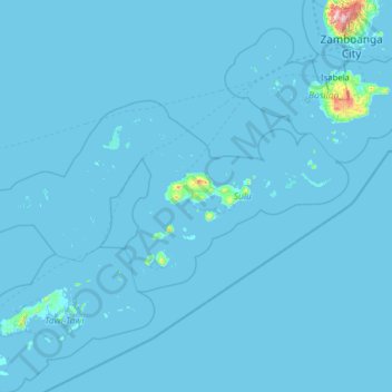
Nombre: Mapa topográfico Sulu, altitud, relieve.
Lugar: Sulu, Zamboanga Peninsula, Philippines (5.31527 119.51643 6.57464 122.08444)
Altitud media: 10 m
Altitud mínima: -1 m
Altitud máxima: 1,290 m
Otros mapas topográficos
Haga clic en un mapa para ver su topografía, su altitud y su relieve.
Quezon City
Founded as a pueblo by Saint Pedro Bautista in 1590, San Francisco del Monte may be considered Quezon City's oldest district. The original land area of the old town of San Francisco del Monte was approximately2.5 square kilometres (1.0 sq mi) and covered parts of what is currently known as Project 7 and 8 and…
Altitud media: 57 m
Mandaluyong
Another claims that the Spaniards named the place based on the report of a navigator named Acapulco, who saw the rolling hills frequently being lashed at by daluyong (“big waves from the sea”). This seems to confirm traditional pre-Hispanic stories that giant waves from the sea would meet the adjoining…
Altitud media: 33 m
Malolos
Malolos is relatively flat of about 0.81% to a gently sloping of 2.17%. The slope of the land descends towards west, southwest to southern direction. The highest land elevation is at about 6.0 meters above sea level while the lowest is only half a meter below sea level. A network of natural waterways and…
Altitud media: 6 m
San Juan
"San Juan" is a contraction of the city's traditional name of "San Juan del Monte" (lit. 'Saint John of the Mountain'). As with numerous other places in the Philippines, the name combines a patron saint and a toponym; in this case Saint John the Baptist with the locale's hilly terrain and relatively higher…
Altitud media: 35 m
Baguio
In 1903, Filipinos, Japanese and Chinese workers were hired to build Kennon Road, the first road directly connecting Baguio with the lowlands of La Union and Pangasinan. Before this, the only road to Benguet was Naguilian Road, and it was largely a horse trail at higher elevations. Camp John Hay was…
Altitud media: 881 m
Bacolod
Bacólod (English: Bacolod), is derived from bakólod (Old Spelling: bacólod), the Old Hiligaynon (Old Ilonggo) (Old Spelling: Ylongo and Ilongo) word for a "hill, turtle, mound, rise, hillock, down, any small eminence or elevation", since the resettlement was founded on a stony, hilly area, now the barangay…
Altitud media: 49 m
Carcar
The land is generally level with less than 18% slope comprising 78.7% of the total land area. Areas with slopes ranging from 18 to 50% cover 19.3% of the total land area and those over 50% slope comprise approximately 1.9%. The highest recorded elevation is a little over 660 metres (2,170 ft) above sea level,…
Altitud media: 97 m
Daraga
67.3% of the total municipal land area has a predominantly low elevation of up to 100 metres (330 ft). The surface terrain is generally characterized by combination of level to nearly level areas, gentle to undulating areas and undulating to rolling areas.
Altitud media: 76 m
San Juan
"San Juan" is a contraction of the city's traditional name of "San Juan del Monte" (lit. 'Saint John of the Mountain'). As with numerous other places in the Philippines, the name combines a patron saint and a toponym; in this case Saint John the Baptist with the locale's hilly terrain and relatively higher…
Altitud media: 35 m
Calape
Most of the coastal area is a fairly level plain that gradually rises into rolling hills of coralline limestone. The highest point in Calape is Mount Candungao in the eastern portion of the town, with an elevation of 150 metres (500 ft) above sea level.
Altitud media: 46 m
Taal Volcano
Philippines > Batangas > San Nicolas
Volcano Island sank from 1 to 3 m (3 to 10 ft) as a result of the eruption. It was also found that the southern shore of Lake Taal sank in elevation from the eruption. No evidences of lava could be discovered anywhere, nor have geologists been able to trace any visible records of a lava flow having occurred at…
Altitud media: 91 m
General Tinio
Farming is the livelihood of majority of the residents. Even though located at the foot of the Sierra Madre Mountain Ridges, the topography is generally plain ideal to agricultural products such as palay and vegetables. A number of poultry broiler contract growers are located in the municipality. Other…
Altitud media: 54 m
Mandaue
It is one of the two (the other one being the municipality of Consolacion) local government units located within the mainland Metro Cebu where the elevation of land is less than 100 m (330 ft).
Altitud media: 109 m
Trece Martires
The city of Trece Martires is characterised with ground elevation ranging from 30m to nearly 400m. Its ground slope ranges from 0.5 to 2%.
Altitud media: 150 m
Valencia
The city's topography is characterized as flat to undulating hills with extensive plateaus and mountainous areas and cliffs on both eastern and western portions bounding the municipality of San Fernando on the east and the municipality of Talakag on the west. Its highest point is Mount Kalatungan in the…
Altitud media: 566 m
Enrile
Enrile is bounded by hills and mountains on both North and West. Area with low elevation is about 20 meters above sea level at the Eastern part which lies close to the river boundaries. The highest elevation is found Northwest which is approximately 800 meters above sea level.
Altitud media: 45 m
Cabadbaran
Philippines > Agusan del Norte
It is 29 kilometres (18 mi) from Butuan. It is generally flat with rolling hills and swamplands in its western part. The highest of all mountains in the Caraga region, Mount Hilong-Hilong (with an altitude of 2,012 metres (6,601 ft) above sea level), rises in this city.
Altitud media: 179 m
Vigan
Vigan is situated in a Quaternary Age sedimentary plain called the Vigan-Bantay Plain which is part of the Ilocos coastal plain. The Vigan-Bantay Plain is bounded on the east by a moderately rugged Miocene sediments consisting of interbedded sandstones and shale to very rugged Meta-volcanics and Meta sediment…
Altitud media: 63 m