
Mapa topográfico Snake River
Mapa interactivo
Haga clic en el mapa para ver la altitud.
Acerca de este mapa
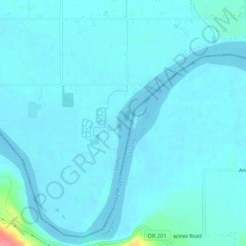
Nombre: Mapa topográfico Snake River, altitud, relieve.
Lugar: Snake River, Washington County, Idaho, United States (44.24055 -117.04422 44.24207 -117.04351)
Altitud media: 643 m
Altitud mínima: 635 m
Altitud máxima: 721 m
Mountain ranges in the Snake watershed include the Teton Range, Bitterroot Range, Clearwater Mountains, Seven Devils Mountains, and the extreme northwestern end of the Wind River Range. Grand Teton is the highest point in the Snake River watershed, reaching 13,775 feet (4,199 m) in elevation. The elevation of the Snake River is 358 feet (109 m) when it joins the Columbia River.[3]
Otros mapas topográficos
Haga clic en un mapa para ver su topografía, su altitud y su relieve.
Midvale
United States > Idaho > Washington County
Midvale, Washington County, Idaho, United States
Altitud media: 794 m
Cambridge
United States > Idaho > Washington County
Cambridge, Washington County, Idaho, United States
Altitud media: 811 m