
Mapa topográfico Cambridge
Mapa interactivo
Haga clic en el mapa para ver la altitud.
Acerca de este mapa
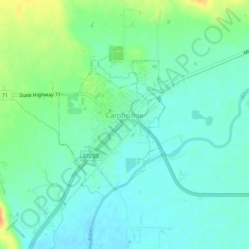
Nombre: Mapa topográfico Cambridge, altitud, relieve.
Lugar: Cambridge, Washington County, Idaho, United States (44.56460 -116.68610 44.57852 -116.66948)
Altitud media: 811 m
Altitud mínima: 799 m
Altitud máxima: 840 m
Cambridge is located at 44°34′18″N 116°40′41″W / 44.57167°N 116.67806°W / 44.57167; -116.67806 (44.571535, −116.678013), at an elevation of 2,661 feet (811 m) above sea level. According to the United States Census Bureau, the city has a total area of 0.49 square miles (1.27 km2), of which, 0.48 square miles (1.24 km2) is land and 0.01 square miles (0.03 km2) is water.
Otros mapas topográficos
Haga clic en un mapa para ver su topografía, su altitud y su relieve.
Midvale
United States > Idaho > Washington County
Midvale, Washington County, Idaho, United States
Altitud media: 794 m
Snake River
United States > Idaho > Washington County
Snake River, Washington County, Idaho, United States
Altitud media: 643 m