
Haz una donación
Mapa topográfico Upper Welland
Haga clic en el mapa para ver la altitud.
Haz una donación
Upper Welland
Upper Welland is a small settled area within the civil parish of Malvern Wells, in Worcestershire, England. Lying close to the county boundaries of Herefordshire.It was formed when the upper part of Welland parish joined the newly created Malvern Hills Urban District. Welland Parish once stretched to the ridge of the Malvern Hills. Its average elevation is 115 metres above the sea level.
Haz una donación
Acerca de este mapa
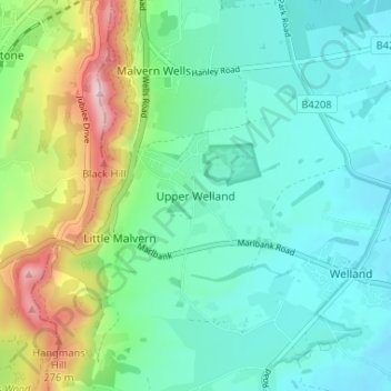
Nombre: Mapa topográfico Upper Welland, altitud, relieve.
Altitud media: 115 m
Altitud mínima: 31 m
Altitud máxima: 356 m
Haz una donación
Otros mapas topográficos
Haga clic en un mapa para ver su topografía, su altitud y su relieve.
Lickey Hills Country Park
United Kingdom > England > Worcestershire > Bromsgrove > Cofton Hackett CP
Altitud media: 209 m
Haz una donación
Broadheath
United Kingdom > England > Worcestershire > Malvern Hills > Lower Broadheath
Altitud media: 44 m
Haz una donación
Haz una donación
Haz una donación
Morton Stanley Park
United Kingdom > England > Worcestershire > Redditch > Callow Hill
Altitud media: 129 m
Stourport Historic Canal Basins
United Kingdom > England > Worcestershire > Wyre Forest > Stourport-on-Severn > Wilden
Altitud media: 33 m
Haz una donación
Haz una donación
Haz una donación
Haz una donación
Haz una donación
River Severn
United Kingdom > England > Worcestershire > Wyre Forest > Stourport-on-Severn
Altitud media: 45 m
West Malvern
United Kingdom > England > Worcestershire > Malvern Hills
West Malvern is a village and a civil parish on the west side of the north part of the Malvern Hills, on the western edge of Worcestershire, England. It has become effectively a suburb of Malvern and part of an urban area often called The Malverns, locally administered by Malvern Hills District Council and its…
Altitud media: 198 m
Haz una donación
Lickey Hills Country Park
United Kingdom > England > Worcestershire > Birmingham > Rednal
Altitud media: 226 m
Haz una donación
Haz una donación
Haz una donación
Haz una donación
Haz una donación
Haz una donación
Ronkswood Hill Meadows Local Nature Reserve
United Kingdom > England > Worcestershire > Worcester
Altitud media: 56 m
Haz una donación
Haz una donación
Badsey Lane Nature Reserve
United Kingdom > England > Worcestershire > Wychavon > Evesham
Altitud media: 37 m
Haz una donación
Clent
United Kingdom > England > Worcestershire > Bromsgrove
Because of the hilly topography of the parish the village consists of several distinct hamlets. These are Upper Clent (Clatterbach and the area around the parish church of St. Leonard), Lower Clent, Holy Cross, Adams Hill and Walton Pool. The Civil Parish of Clent also included part of the village of West…
Altitud media: 184 m
Haz una donación
Tiddesley Wood
United Kingdom > England > Worcestershire > Wychavon > Pershore > Pensham
Altitud media: 28 m
Haz una donación
Haz una donación
Haz una donación
Haz una donación
Haz una donación