
Mapa topográfico Melton
Haga clic en el mapa para ver la altitud.
Acerca de este mapa
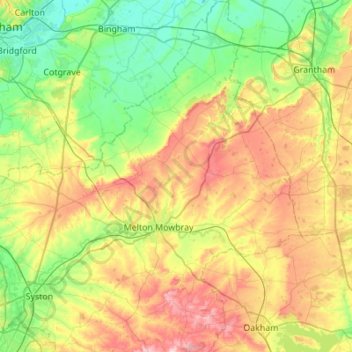
Nombre: Mapa topográfico Melton, altitud, relieve.
Lugar: Melton, Leicestershire, England, United Kingdom (52.64585 -1.04663 52.97766 -0.66411)
Altitud media: 92 m
Altitud mínima: 14 m
Altitud máxima: 232 m
Otros mapas topográficos
Haga clic en un mapa para ver su topografía, su altitud y su relieve.
Kelham Bridge Nature Reserve
United Kingdom > England > Leicestershire > North West Leicestershire > Ravenstone
Altitud media: 139 m
Market Bosworth Country Park
United Kingdom > England > Leicestershire > Hinckley and Bosworth > Market Bosworth
Altitud media: 119 m
Isley Walton
United Kingdom > England > Leicestershire > North West Leicestershire
Altitud media: 76 m
Watermead Country Park
United Kingdom > England > Leicestershire > Charnwood > Birstall
Altitud media: 59 m
Brocks Hill
United Kingdom > England > Leicestershire > Oadby and Wigston > Oadby
Altitud media: 102 m
Thringstone
United Kingdom > England > Leicestershire > North West Leicestershire
Altitud media: 126 m
Adrian's Spinney
United Kingdom > England > Leicestershire > Harborough > Stoughton
Altitud media: 113 m
Lount Wood
United Kingdom > England > Leicestershire > North West Leicestershire > Lount
Altitud media: 131 m
Stretton Baskerville
United Kingdom > England > Leicestershire > Hinckley and Bosworth
Altitud media: 111 m
Breedon on the Hill
United Kingdom > England > Leicestershire > North West Leicestershire
Altitud media: 84 m
Bradgate Park
United Kingdom > England > Leicestershire > Charnwood > Newtown Linford
Overlying the Beacon Hill Formation, but found a little further down the hillside to the south, are the Bradgate Formation beds, the most notable of which is the Sliding Stone Slump Breccia rocks. Forming a line of crags below Old John, these are laminated mudstones, with layers of sandstone, mainly of…
Altitud media: 126 m
Top Town Plantation
United Kingdom > England > Leicestershire > Charnwood > Walton on the Wolds
Altitud media: 85 m
Eye Kettleby
United Kingdom > England > Leicestershire > Borough of Melton > Melton Mowbray
Altitud media: 95 m
Ingarsby
United Kingdom > England > Leicestershire > Harborough District > Ingarsby
Altitud media: 139 m
Eyebrook Reservoir
United Kingdom > England > Leicestershire > Harborough District > Stockerston
Altitud media: 85 m
Billa Barra Hill
United Kingdom > England > Leicestershire > Hinckley and Bosworth > Stanton under Bardon
Altitud media: 191 m
Upper Bruntingthorpe
United Kingdom > England > Leicestershire > Harborough District > Walton > Upper Bruntingthorpe
Altitud media: 143 m
Nailstone Colliery Railway
United Kingdom > England > Leicestershire > North West Leicestershire > Ibstock
Altitud media: 155 m
Sence Valley Country Park
United Kingdom > England > Leicestershire > North West Leicestershire > Heather
Altitud media: 131 m
Great Easton
United Kingdom > England > Leicestershire > Harborough District > Great Easton
Altitud media: 72 m
Catthorpe
United Kingdom > England > Leicestershire > Harborough District > Catthorpe
Altitud media: 113 m
Long Whatton
United Kingdom > England > Leicestershire > North West Leicestershire
Altitud media: 63 m
Barton in the Beans
United Kingdom > England > Leicestershire > Hinckley and Bosworth
Altitud media: 113 m
Higham on the Hill
United Kingdom > England > Leicestershire > Hinckley and Bosworth
Altitud media: 96 m
Timberwood Hill
United Kingdom > England > Leicestershire > North West Leicestershire
Altitud media: 192 m
Breedon Cloud Wood
United Kingdom > England > Leicestershire > North West Leicestershire > Breedon on the Hill
Altitud media: 90 m
Swannymote Rock
United Kingdom > England > Leicestershire > North West Leicestershire > Coalville
Altitud media: 139 m
Willesley Woods
United Kingdom > England > Leicestershire > North West Leicestershire > Ashby-de-la-Zouch > Willesley
Altitud media: 108 m
Merry Lees
United Kingdom > England > Leicestershire > Hinckley and Bosworth > Botcheston
Altitud media: 126 m
Kilby Bridge
United Kingdom > England > Leicestershire > Oadby and Wigston > Wigston
Altitud media: 89 m