
Haz una donación
Mapa topográfico Higham on the Hill
Haga clic en el mapa para ver la altitud.
Haz una donación
Acerca de este mapa
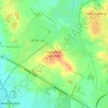
Nombre: Mapa topográfico Higham on the Hill, altitud, relieve.
Altitud media: 96 m
Altitud mínima: 79 m
Altitud máxima: 124 m
Haz una donación
Otros mapas topográficos
Haga clic en un mapa para ver su topografía, su altitud y su relieve.
Market Bosworth Country Park
United Kingdom > England > Leicestershire > Hinckley and Bosworth > Market Bosworth
Altitud media: 119 m
Markfield
United Kingdom > England > Leicestershire > Hinckley and Bosworth > Markfield
Altitud media: 174 m
Haz una donación
Burbage
United Kingdom > England > Leicestershire > Hinckley and Bosworth > Stretton Baskerville
Altitud media: 110 m
Thornton Reservoir
United Kingdom > England > Leicestershire > Hinckley and Bosworth > Thornton
Altitud media: 139 m
Haz una donación
Higham on the Hill
United Kingdom > England > Leicestershire > Hinckley and Bosworth
Altitud media: 94 m
Haz una donación
Desford
United Kingdom > England > Leicestershire > Hinckley and Bosworth > Botcheston
Altitud media: 115 m
Market Bosworth
United Kingdom > England > Leicestershire > Hinckley and Bosworth
Altitud media: 103 m
Haz una donación
Billa Barra Hill
United Kingdom > England > Leicestershire > Hinckley and Bosworth > Stanton under Bardon
Altitud media: 191 m
Bagworth Heath Woods
United Kingdom > England > Leicestershire > Hinckley and Bosworth > Thornton
Altitud media: 138 m
Haz una donación
Burroughs Wood
United Kingdom > England > Leicestershire > Hinckley and Bosworth > Botcheston
Altitud media: 114 m
Stanton-under-Bardon
United Kingdom > England > Leicestershire > Hinckley and Bosworth
Altitud media: 171 m
Haz una donación