
Haz una donación
Mapa topográfico Kodaikanal
Haga clic en el mapa para ver la altitud.
Haz una donación
Kodaikanal
Kodaikanal (Tamil: [ko'ɖaɪ'kaːnəl]) (English: ko-DYE-KAH-null) is a town and hill station in Dindigul district in the state of Tamil Nadu, India. It is situated at an altitude of 2,225 m (7,300 ft) in the Palani hills of the Western Ghats. Kodaikanal was established in 1845 to serve as a refuge from the high temperatures and tropical diseases during the summer in the plains. It is a popular tourist destination and is referred to as the "Princess of Hill stations" with much of the local economy is based on the hospitality industry serving tourism. As per the 2011 census, the city had a population of 36,501.
Haz una donación
Acerca de este mapa
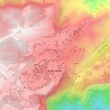
Nombre: Mapa topográfico Kodaikanal, altitud, relieve.
Lugar: Kodaikanal, Dindigul, Tamil Nadu, India (10.21896 77.46361 10.26278 77.51512)
Altitud media: 1,976 m
Altitud mínima: 985 m
Altitud máxima: 2,322 m
Haz una donación
Otros mapas topográficos
Haga clic en un mapa para ver su topografía, su altitud y su relieve.
Kodaikanal
India > Tamil Nadu > Kodaikanal > Kodaikanal
Kodaikanal has a monsoon-influenced subtropical highland climate (Cfb, according to the Köppen climate classification, with a Cwb tendency). The temperatures are cool throughout the year due to the high elevation of the city.
Altitud media: 1,763 m
Haz una donación
Haz una donación
Haz una donación
Haz una donación
Haz una donación