
Gracias por apoyar a este sitio ❤️
Haz una donación
Haz una donación
Mapa topográfico Kodaikanal Solar Observatory
Haga clic en el mapa para ver la altitud.
Gracias por apoyar a este sitio ❤️
Haz una donación
Haz una donación
Acerca de este mapa
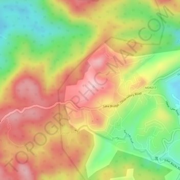
Nombre: Mapa topográfico Kodaikanal Solar Observatory, altitud, relieve.
Altitud media: 2,238 m
Altitud mínima: 2,111 m
Altitud máxima: 2,337 m
Gracias por apoyar a este sitio ❤️
Haz una donación
Haz una donación
Otros mapas topográficos
Haga clic en un mapa para ver su topografía, su altitud y su relieve.
Kodaikanal
India > Tamil Nadu > Kodaikanal > Kodaikanal
Kodaikanal has a monsoon-influenced subtropical highland climate (Cfb, according to the Köppen climate classification, with a Cwb tendency). The temperatures are cool throughout the year due to the high elevation of the city.
Altitud media: 1,763 m