
Gracias por apoyar a este sitio ❤️
Haz una donación
Haz una donación
Mapa topográfico Magallanes
Haga clic en el mapa para ver la altitud.
Gracias por apoyar a este sitio ❤️
Haz una donación
Haz una donación
Magallanes
The topography of the land is mostly flat and rolling, surrounded by mountains. Swamps characterize much of the landscape that is situated at the mouth of the two major rivers in the province, the Agusan and Baug Rivers.
Gracias por apoyar a este sitio ❤️
Haz una donación
Haz una donación
Acerca de este mapa
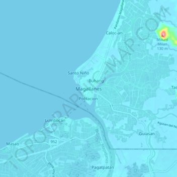
Nombre: Mapa topográfico Magallanes, altitud, relieve.
Lugar: Magallanes, Agusan del Norte, Caraga, 8604, Philippines (8.98371 125.47851 9.06371 125.55851)
Altitud media: 3 m
Altitud mínima: 0 m
Altitud máxima: 136 m
Gracias por apoyar a este sitio ❤️
Haz una donación
Haz una donación
Otros mapas topográficos
Haga clic en un mapa para ver su topografía, su altitud y su relieve.