
Haz una donación
Mapa topográfico Kitcharao
Haga clic en el mapa para ver la altitud.
Haz una donación
Acerca de este mapa
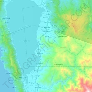
Nombre: Mapa topográfico Kitcharao, altitud, relieve.
Lugar: Kitcharao, Agusan del Norte, Caraga, 8609, Philippines (9.36824 125.52051 9.46838 125.74906)
Altitud media: 293 m
Altitud mínima: 0 m
Altitud máxima: 1,723 m
Haz una donación
Otros mapas topográficos
Haga clic en un mapa para ver su topografía, su altitud y su relieve.
Cabadbaran
Philippines > Agusan del Norte
It is 29 kilometres (18 mi) from Butuan. It is generally flat with rolling hills and swamplands in its western part. The highest of all mountains in the Caraga region, Mount Hilong-Hilong (with an altitude of 2,012 metres (6,601 ft) above sea level), rises in this city.
Altitud media: 179 m
Haz una donación
Jabonga
Philippines > Agusan del Norte
The topography of the land features plain to rolling and hills. Among the municipalities, Jabonga ranks first in total area and number of farms (464) mostly owned by individuals. It has one of the 36 crop storage facilities of the province. Its major crops are coconut, rice, corn, timber and both fresh and…
Altitud media: 116 m
Haz una donación
Haz una donación
Haz una donación
Haz una donación
Haz una donación
Haz una donación
Haz una donación
Cabadbaran
Philippines > Agusan del Norte
It is generally flat with rolling hills and swamplands in its western part. The highest of all mountains in the Caraga region, Mount Hilong-Hilong (with an altitude of 2,012 metres (6,601 ft) above sea level), rises in this city.
Altitud media: 179 m
Haz una donación
Haz una donación
Magallanes
Philippines > Agusan del Norte
The topography of the land is mostly flat and rolling, surrounded by mountains. Swamps characterize much of the landscape that is situated at the mouth of the two major rivers in the province, the Agusan and Baug Rivers.
Altitud media: 3 m
Jabonga
Philippines > Agusan del Norte
The topography of the land features plain to rolling and hills. Among the municipalities, Jabonga ranks first in total area and number of farms (464) mostly owned by individuals. It has one of the 36 crop storage facilities of the province. Its major crops are coconut, rice, corn, timber and both fresh and…
Altitud media: 116 m
Haz una donación