
Mapa topográfico Pittington
Haga clic en el mapa para ver la altitud.
Acerca de este mapa
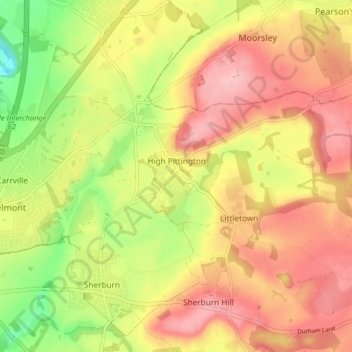
Nombre: Mapa topográfico Pittington, altitud, relieve.
Lugar: Pittington, County Durham, North East, England, United Kingdom (54.77824 -1.51783 54.80248 -1.43648)
Altitud media: 101 m
Altitud mínima: 20 m
Altitud máxima: 162 m
Otros mapas topográficos
Haga clic en un mapa para ver su topografía, su altitud y su relieve.
High Shincliffe
United Kingdom > England > County Durham
High Shincliffe is a village in County Durham, England. It is situated about two miles south-east of Durham City, on the A177 road to Stockton-on-Tees. The altitude of High Shincliffe is approximately 90 metres (300 ft), and it lies 55 metres (180 ft) above the River Wear at Shincliffe bridge. Latest…
Altitud media: 77 m
South Agnew Plantation
United Kingdom > England > County Durham > Newton Aycliffe
Altitud media: 100 m
South Moor
United Kingdom > England > County Durham > Stanley > Quaking Houses > South Moor
Altitud media: 202 m
West Shield Row Villas
United Kingdom > England > County Durham > Stanley > Tanfield Lea
Altitud media: 180 m
Mickle Fell
United Kingdom > England > County Durham
Mickle Fell is a mountain in the Pennines, the range of hills and moors running down the middle of Northern England. It has a maximum elevation of 788 m (2,585 ft). It lies slightly off the main watershed of the Pennines, about 10 miles (16 kilometres) south of Cross Fell. After Cross Fell, Mickle Fell is the…
Altitud media: 658 m