
Mapa topográfico Gschwender Horn
Mapa interactivo
Haga clic en el mapa para ver la altitud.
Acerca de este mapa
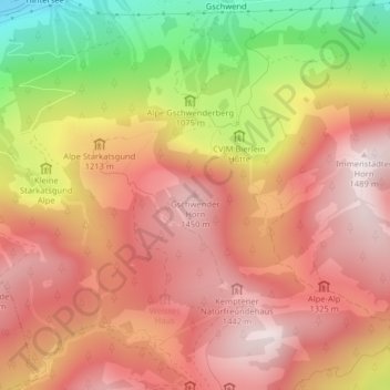
Nombre: Mapa topográfico Gschwender Horn, altitud, relieve.
Altitud media: 1,200 m
Altitud mínima: 724 m
Altitud máxima: 1,484 m
Otros mapas topográficos
Haga clic en un mapa para ver su topografía, su altitud y su relieve.
Knottenried
Deutschland > Bayern > Landkreis Oberallgäu > Immenstadt im Allgäu
Knottenried, Immenstadt im Allgäu, Landkreis Oberallgäu, Bayern, 87509, Deutschland
Altitud media: 948 m