
Mapa topográfico Knottenried
Haga clic en el mapa para ver la altitud.
Knottenried
Der Höhenfestpunkt für Knottenried ist in die Mauer der Pfarrkirche eingeschlagen und liegt auf 1003 m über NHN. Der mit 1056 m ü. NHN höchste Punkt der Pfarrei ist westlich von Knottenried auf der im amtlichen Grundbeschrieb als „Prageck“ benannten Flurbezeichnung. Der tiefste Punkt ist das Mühlbach-Tobel südlichöstlich von Reute am Übergang zur Gemarkung Akams mit 900 m über NHN.
Acerca de este mapa
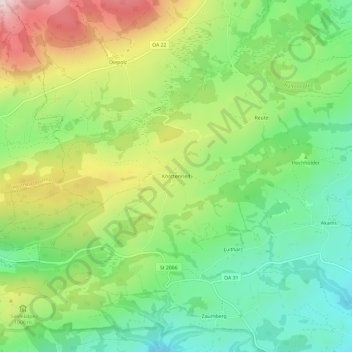
Nombre: Mapa topográfico Knottenried, altitud, relieve.
Altitud media: 948 m
Altitud mínima: 766 m
Altitud máxima: 1,235 m
Otros mapas topográficos
Haga clic en un mapa para ver su topografía, su altitud y su relieve.
Großer Alpsee
Deutschland > Bayern > Landkreis Oberallgäu > Immenstadt im Allgäu > Bühl am Alpsee
Weniger als 200 Meter oberhalb des westlichen Ufers liegt der 4,6 ha große Teufelssee, ein Restgewässer aus der Zeit, als der See noch weiter nach Westen reichte. Er liegt im Naturpark Nagelfluhkette und grenzt im Norden an den Salmaser Höhenzug, der die nördliche Grenze der Allgäuer Alpen darstellt. Im…
Altitud media: 821 m
Kleiner Alpsee
Deutschland > Bayern > Landkreis Oberallgäu > Immenstadt im Allgäu > Bühl am Alpsee
Altitud media: 855 m