
Mapa topográfico Eastern Ghats
Mapa interactivo
Haga clic en el mapa para ver la altitud.
Acerca de este mapa
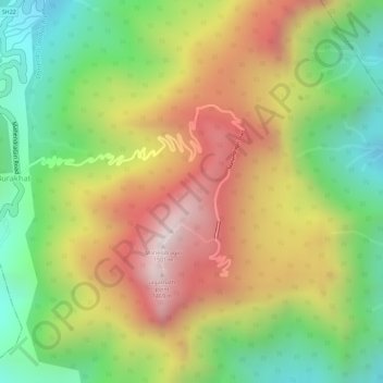
Nombre: Mapa topográfico Eastern Ghats, altitud, relieve.
Altitud media: 1,130 m
Altitud mínima: 777 m
Altitud máxima: 1,494 m
The Maliya Range is located in the northern portion of the Eastern Ghats, generally ranging between elevations of 900–1,200 m. The tallest peak in this range is Mahendragiri (1,501 m).
Otros mapas topográficos
Haga clic en un mapa para ver su topografía, su altitud y su relieve.
Mahendragiri
India > Odisha > Ramagiri > Burakhat
Mahendragiri, Burakhat, Ramagiri, Gajapati District, Odisha, India
Altitud media: 1,108 m