
Mapa topográfico Tagaytay
Mapa interactivo
Haga clic en el mapa para ver la altitud.
Acerca de este mapa
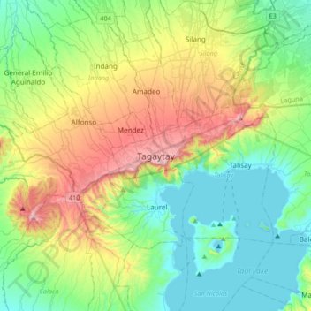
Nombre: Mapa topográfico Tagaytay, altitud, relieve.
Lugar: Tagaytay, Cavite, Calabarzon, 4120, Philippines (13.94333 120.77209 14.26333 121.09209)
Altitud media: 229 m
Altitud mínima: -3 m
Altitud máxima: 762 m
The southern and eastern portions of Tagaytay are covered by hills and mountains which is generally forests, pine trees and open grasslands. The city lies along Tagaytay Ridge, a ridge stretching about 32 kilometres (20 mi) from Mount Batulao in the west to Mount Sungay in the east with elevations averaging about 610 metres (2,000 ft) above sea level. Mount Sungay, in Tagaytay, is the highest point of the province of Cavite at 709 metres (2,326 ft).