
Mapa topográfico Santa Barbara
Mapa interactivo
Haga clic en el mapa para ver la altitud.
Acerca de este mapa
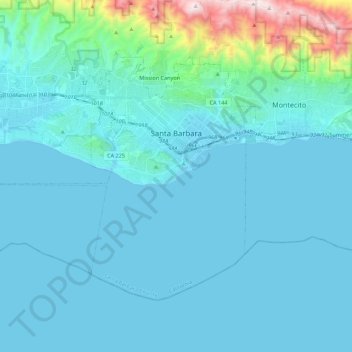
Nombre: Mapa topográfico Santa Barbara, altitud, relieve.
Altitud media: 119 m
Altitud mínima: -1 m
Altitud máxima: 1,155 m
Annual rainfall totals are highly variable and in exceptional years like 1940–1941 and 1997–1998 over 40 inches (1.0 m) of rain have fallen in a year, but in dry seasons less than 6 inches (150 mm) is not unheard of. Snow sometimes covers higher elevations of the Santa Ynez Mountains but is extremely rare in the city itself. The most recent accumulating snow to fall near sea level was in January 1949, when approximately two inches fell in the city.