
Haz una donación
Mapa topográfico Palladam
Haga clic en el mapa para ver la altitud.
Haz una donación
Palladam
Palladam is located at 10°59′N 77°18′E / 10.98°N 77.3°E / 10.98; 77.3. It has an average elevation of 325 metres (1,066 feet). Palladam is located near to Tirupur (14 km away) which is called the 'Dollar City' of Tamil Nadu, 15 km from the village of Putharachal and located 38 km east of the city of Coimbatore, ‘‘‘Manchester of South India‘‘‘ . Palladam is the gateway to Coimbatore from the eastern and south-eastern parts of Tamil Nadu. The soil is predominantly Red, suitable for cultivating vegetables and other cash crops.
Haz una donación
Acerca de este mapa
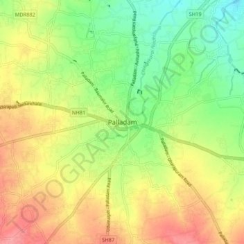
Nombre: Mapa topográfico Palladam, altitud, relieve.
Lugar: Palladam, Tiruppur, Tamil Nadu, 638664, India (10.95623 77.24356 11.03623 77.32356)
Altitud media: 377 m
Altitud mínima: 336 m
Altitud máxima: 421 m
Haz una donación