Geolocalizar

Mapa topográfico Leece

Mapa interactivo

Haga clic en el mapa para ver la altitud.

Acerca de este mapa

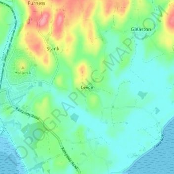
Nombre: Mapa topográfico Leece, altitud, relieve.

Lugar: Leece, South Lakeland, Westmorland and Furness, England, LA12 0QS, United Kingdom (54.09511 -3.18032 54.13511 -3.14032)

Altitud media: 25 m

Altitud mínima: 0 m

Altitud máxima: 92 m

Otros mapas topográficos

Haga clic en un mapa para ver su topografía, su altitud y su relieve.

Scout Scar

United Kingdom > England > Westmorland and Furness > South Lakeland > Brigsteer

Scout Scar, Underbarrow and Bradleyfield, Brigsteer, South Lakeland, Westmorland and Furness, England, LA8 8BJ, United Kingdom

Altitud media: 130 m

Pool Bank

United Kingdom > England > Westmorland and Furness > South Lakeland

Pool Bank, Crosthwaite and Lyth, South Lakeland, Westmorland and Furness, England, LA11 6SB, United Kingdom

Altitud media: 80 m

Roudsea Wood

United Kingdom > England > Westmorland and Furness > South Lakeland > Haverthwaite

Roudsea Wood, Haverthwaite, South Lakeland, Westmorland and Furness, England, United Kingdom

Altitud media: 7 m

Black Force

United Kingdom > England > Westmorland and Furness > South Lakeland

Black Force, South Lakeland, Westmorland and Furness, England, LA8 0BT, United Kingdom

Altitud media: 437 m

Deepdale Beck

United Kingdom > England > Westmorland and Furness > South Lakeland > Dent

Deepdale Beck, Dent, South Lakeland, Westmorland and Furness, England, United Kingdom

Altitud media: 280 m