
Haz una donación
Mapa topográfico Chakdaha
Haga clic en el mapa para ver la altitud.
Haz una donación
Chakdaha
Chakdaha is a prominent urban local body in the district of Nadia, one of the southern districts of West Bengal. Chakdaha's location is 23°05′N 88°31′E / 23.08°N 88.52°E / 23.08; 88.52. It has an average elevation of 11 meters (36 feet) and is 62 km north of the state capital, Kolkata. It is on National Highway 12 (old number NH 34), an approximate 2-hour drive from Kolkata via the National Highway NH12. Regular public transport operates from Madhyamgram (near Kolkata) to Chakdaha, with low-cost buses running every 20 minutes during the day time.
Haz una donación
Acerca de este mapa
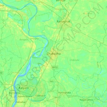
Nombre: Mapa topográfico Chakdaha, altitud, relieve.
Lugar: Chakdaha, Nadia, West Bengal, 741222, India (22.91750 88.37204 23.23750 88.69204)
Altitud media: 10 m
Altitud mínima: -3 m
Altitud máxima: 30 m
Haz una donación
Otros mapas topográficos
Haga clic en un mapa para ver su topografía, su altitud y su relieve.