
Haz una donación
Mapa topográfico Vista Grande
Haga clic en el mapa para ver la altitud.
Haz una donación
Acerca de este mapa
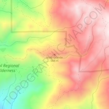
Nombre: Mapa topográfico Vista Grande, altitud, relieve.
Lugar: Vista Grande, Alameda County, California, United States (37.52967 -121.81116 37.52977 -121.81106)
Altitud media: 476 m
Altitud mínima: 144 m
Altitud máxima: 704 m
Haz una donación
Otros mapas topográficos
Haga clic en un mapa para ver su topografía, su altitud y su relieve.
Quarry Lakes Regional Park
United States > California > Alameda County > Fremont > Eberly
Altitud media: 17 m
Haz una donación
Dougherty Hills Open Space
United States > California > Alameda County > Dublin > Komandorski Village
Altitud media: 120 m
Haz una donación
Reinhardt-Redwood Regional Park
United States > California > Alameda County > Oakland
Altitud media: 292 m
Lake Del Valle
United States > California > Alameda County
The dam is 230 feet (70 m) high and 880 feet (270 m) long. Its crest elevation is 773 feet (236 m). The dam contains 4,150,000 cubic yards (3,170,000 m3) of earth fill.
Altitud media: 339 m
Haz una donación