
Haz una donación
Mapa topográfico Springbok
Haga clic en el mapa para ver la altitud.
Haz una donación
Springbok
The town lies at an elevation of 1,007 metres (3,304 feet) in a narrow valley between the high granite domes of the Klein Koperberge (Small Copper Mountains). This name gives away the reason for the early settlement which gradually turned into a major commercial and administrative centre for copper mining operations in the region. While the town initially developed rapidly, this slowed when rich copper deposits were discovered in Okiep. As the main source of water, Springbok continued to develop as the commercial and administrative centre for different mines in the area. Even though mining activities have dwindled, the town remains an important administrative capital in the region and due to its location a favourite stopover for tourists on their way to Namibia. Today the main income is generated from tourism, mining activities, commerce and farming.
Haz una donación
Acerca de este mapa
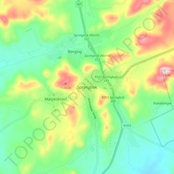
Nombre: Mapa topográfico Springbok, altitud, relieve.
Altitud media: 927 m
Altitud mínima: 768 m
Altitud máxima: 1,228 m
Haz una donación
Otros mapas topográficos
Haga clic en un mapa para ver su topografía, su altitud y su relieve.
Buffels
South Africa > Northern Cape > Namakwa District Municipality > Nama Khoi Local Municipality > Kleinsee
Altitud media: 18 m