
Gracias por apoyar a este sitio ❤️
Haz una donación
Haz una donación
Mapa topográfico Sindangan
Haga clic en el mapa para ver la altitud.
Gracias por apoyar a este sitio ❤️
Haz una donación
Haz una donación
Sindangan
It was also in this same year that the province of Zamboanga was incorporated and the said towns were later transferred to the newly created province out from their mother province of Misamis. However, despite the elevation of Sindangan’s status as a municipal district, it remained unconnected by road to other towns and barrios, making only sea travel as the primary mode of transportation to reach the seat of government in Lubungan.
Gracias por apoyar a este sitio ❤️
Haz una donación
Haz una donación
Acerca de este mapa
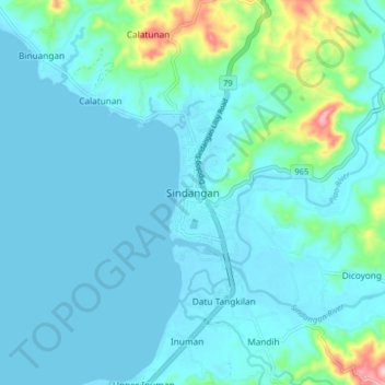
Nombre: Mapa topográfico Sindangan, altitud, relieve.
Altitud media: 30 m
Altitud mínima: -2 m
Altitud máxima: 220 m
Gracias por apoyar a este sitio ❤️
Haz una donación
Haz una donación
Otros mapas topográficos
Haga clic en un mapa para ver su topografía, su altitud y su relieve.