
Haz una donación
Mapa topográfico Henley-on-Thames
Haga clic en el mapa para ver la altitud.
Haz una donación
Acerca de este mapa
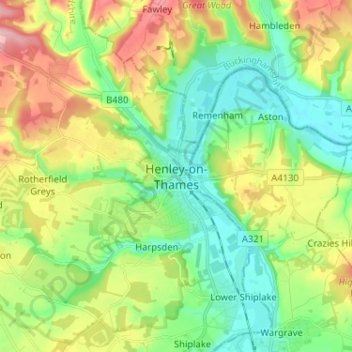
Nombre: Mapa topográfico Henley-on-Thames, altitud, relieve.
Altitud media: 78 m
Altitud mínima: 26 m
Altitud máxima: 169 m
Haz una donación
Otros mapas topográficos
Haga clic en un mapa para ver su topografía, su altitud y su relieve.
Clifton Hampden
United Kingdom > England > Oxfordshire > South Oxfordshire > Clifton Hampden
Altitud media: 58 m
Harpsden Wood
United Kingdom > England > Oxfordshire > South Oxfordshire > Henley-on-Thames > Harpsden
Altitud media: 63 m
Haz una donación
Watlington Hill
United Kingdom > England > Oxfordshire > South Oxfordshire > Watlington
Altitud media: 189 m
Kingwood Common
United Kingdom > England > Oxfordshire > South Oxfordshire > Highmoor
Altitud media: 125 m
Haz una donación
Goring-on-Thames
United Kingdom > England > Oxfordshire > South Oxfordshire > Goring-on-Thames
Altitud media: 87 m
Cowleaze Wood
United Kingdom > England > Oxfordshire > South Oxfordshire > Lewknor
Altitud media: 209 m
Sonning Eye
United Kingdom > England > Oxfordshire > South Oxfordshire > Dunsden Green > Sonning Eye
Altitud media: 44 m
Haz una donación
Haz una donación
Haz una donación
Haz una donación
Haz una donación
Haz una donación
Kidmore End
United Kingdom > England > Oxfordshire > South Oxfordshire > Kidmore End
Altitud media: 94 m
Haz una donación
Chinnor Quarry 2B
United Kingdom > England > Oxfordshire > South Oxfordshire > Kingston Blount > Crowell
Altitud media: 163 m
Whitchurch-on-Thames
United Kingdom > England > Oxfordshire > South Oxfordshire > Whitchurch-on-Thames
Altitud media: 84 m
Haz una donación
Edmonds Park
United Kingdom > England > Oxfordshire > South Oxfordshire > Didcot > East Hagbourne
Altitud media: 68 m
Rotherfield Peppard
United Kingdom > England > Oxfordshire > South Oxfordshire > Rotherfield Peppard
Altitud media: 115 m
Haz una donación
Shirburn
United Kingdom > England > Oxfordshire > South Oxfordshire
Shirburn is a village and civil parish about 6 miles (10 km) south of Thame in Oxfordshire. It contains the Grade I listed, 14th-century Shirburn Castle, along with its surrounding, Grade II listed park, and a parish church, the oldest part of which is from the Norman period. The parish has a high altitude by…
Altitud media: 140 m
Haz una donación
Brightwell Baldwin
United Kingdom > England > Oxfordshire > South Oxfordshire > Cuxham
Altitud media: 97 m
Sonning Common
United Kingdom > England > Oxfordshire > South Oxfordshire > Sonning Common
Altitud media: 88 m
Haz una donación
Haz una donación
East Hagbourne
United Kingdom > England > Oxfordshire > South Oxfordshire > East Hagbourne
Altitud media: 62 m
Haz una donación
Stanton St John
United Kingdom > England > Oxfordshire > South Oxfordshire > Stanton St John
Altitud media: 86 m
Haz una donación
Haz una donación
Aston Rowant Nature Reserve
United Kingdom > England > Oxfordshire > South Oxfordshire > Lewknor
Altitud media: 192 m
Haz una donación
Warborough
United Kingdom > England > Oxfordshire > South Oxfordshire > Warborough
Altitud media: 53 m
Haz una donación
Holly Wood
United Kingdom > England > Oxfordshire > South Oxfordshire > Stanton St John
Altitud media: 80 m
Haz una donación