
Haz una donación
Mapa topográfico Duddington
Haga clic en el mapa para ver la altitud.
Haz una donación
Acerca de este mapa
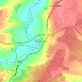
Nombre: Mapa topográfico Duddington, altitud, relieve.
Altitud media: 67 m
Altitud mínima: 26 m
Altitud máxima: 98 m
Haz una donación
Otros mapas topográficos
Haga clic en un mapa para ver su topografía, su altitud y su relieve.
Haz una donación
Irchester Country Park
United Kingdom > England > North Northamptonshire > Little Irchester
Altitud media: 60 m
Haz una donación
River Nene Navigation
United Kingdom > England > North Northamptonshire > Irchester
Altitud media: 55 m
Haz una donación
Haz una donación
Haz una donación
Haz una donación
Irchester
United Kingdom > England > North Northamptonshire
The 12th-century English historian Henry of Huntingdon mentions a Roman "town on the river (Nene), in Huntingdonshire, which is entirely destroyed" as one of his interpretations of the 28 cities of Britain. The town is mentioned also by William Lambarde in Dictionarium Angliae Topographicum & Historicum.
Altitud media: 62 m
Haz una donación
Haz una donación
Haz una donación
Haz una donación
Easton on the Hill
United Kingdom > England > North Northamptonshire > Easton on the Hill
Altitud media: 71 m
Haz una donación
Barton Seagrave
United Kingdom > England > North Northamptonshire
Other natives of the village include topographer John Bridges and his brother, Charles, a painter.
Altitud media: 78 m
Haz una donación
Haz una donación
Haz una donación
Haz una donación
Finedon
United Kingdom > England > North Northamptonshire
The town of Finedon rises to approximately 90 metres Above Ordinance Datum from the River Ise, with the historical centre of the settlement occupying a shallow south-west facing valley. The contemporary point of maximum elevation in the parish is the summit of the disused Sidegate Lane Landfill Site, located…
Altitud media: 75 m
Irchester
United Kingdom > England > North Northamptonshire
The 12th-century English historian Henry of Huntingdon mentions a Roman "town on the river (Nene), in Huntingdonshire, which is entirely destroyed" as one of his interpretations of the 28 cities of Britain. The town is mentioned also by William Lambarde in Dictionarium Angliae Topographicum & Historicum.
Altitud media: 62 m
Haz una donación
Haz una donación
Haz una donación