
Gracias por apoyar a este sitio ❤️
Haz una donación
Haz una donación
Mapa topográfico Maxwell
Haga clic en el mapa para ver la altitud.
Gracias por apoyar a este sitio ❤️
Haz una donación
Haz una donación
Acerca de este mapa
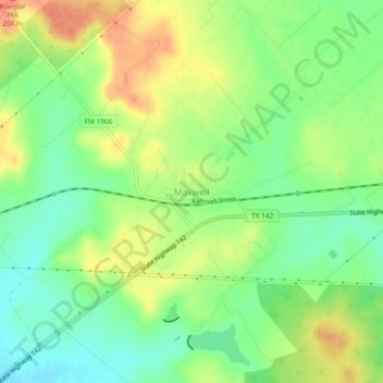
Nombre: Mapa topográfico Maxwell, altitud, relieve.
Lugar: Maxwell, Caldwell County, Texas, 78656, United States (29.86190 -97.81564 29.90190 -97.77564)
Altitud media: 185 m
Altitud mínima: 163 m
Altitud máxima: 209 m
Gracias por apoyar a este sitio ❤️
Haz una donación
Haz una donación
Otros mapas topográficos
Haga clic en un mapa para ver su topografía, su altitud y su relieve.
Lockhart State Park
United States > Texas > Caldwell County > Lockhart
The park features roughly four miles of designated trails that cover a wide range of environments. In addition to multiple short, shade covered trails along the creek in a riparian zone, a network of natural trails traversing multiple hillsides and ravines is located on the backside of the park. A moderate…
Altitud media: 165 m
Gracias por apoyar a este sitio ❤️
Haz una donación
Haz una donación