
Mapa topográfico Fletcher
Mapa interactivo
Haga clic en el mapa para ver la altitud.
Acerca de este mapa
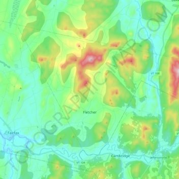
Nombre: Mapa topográfico Fletcher, altitud, relieve.
Lugar: Fletcher, Franklin County, Vermont, 05448, United States (44.64571 -73.00471 44.76055 -72.78366)
Altitud media: 229 m
Altitud mínima: 103 m
Altitud máxima: 610 m
Fletcher is located in southern Franklin County, bordered to the southeast by Lamoille County. According to the United States Census Bureau, the town has a total area of 38.0 square miles (98.4 km2), of which 37.7 square miles (97.7 km2) is land and 0.3 square miles (0.7 km2), or 0.71%, is water. The Lamoille River forms the short southern boundary of the town. Metcalf Pond is located in the north-central part of town. Fletcher Mountain, with a summit elevation of 2,150 feet (660 m), is located at the eastern end of town.
Otros mapas topográficos
Haga clic en un mapa para ver su topografía, su altitud y su relieve.
Fairfield
United States > Vermont > Franklin County
Fairfield, Franklin County, Vermont, 05455, United States
Altitud media: 215 m
Sanderson Corner
United States > Vermont > Franklin County > Fairfax
Sanderson Corner, Fairfax, Franklin County, Vermont, United States
Altitud media: 165 m
Montgomery
United States > Vermont > Franklin County
Montgomery, Franklin County, Vermont, United States
Altitud media: 428 m
Saint Albans
United States > Vermont > Franklin County
Saint Albans, Franklin County, Vermont, United States
Altitud media: 143 m
Coombs Hill
United States > Vermont > Franklin County > Fletcher
Coombs Hill, Fletcher, Franklin County, Vermont, 05448, United States
Altitud media: 372 m
Enosburg Center
United States > Vermont > Franklin County > Enosburg > Enosburg Center
Enosburg Center, Enosburg, Franklin County, Vermont, 05450, United States
Altitud media: 231 m
Franklin County
United States > Vermont > Franklin County
Franklin County, Vermont, United States
Altitud media: 233 m