
Mapa topográfico Rinkerode
Mapa interactivo
Haga clic en el mapa para ver la altitud.
Acerca de este mapa
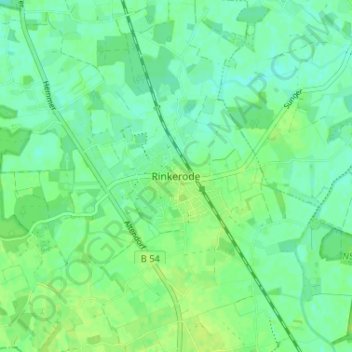
Nombre: Mapa topográfico Rinkerode, altitud, relieve.
Altitud media: 60 m
Altitud mínima: 54 m
Altitud máxima: 65 m
Otros mapas topográficos
Haga clic en un mapa para ver su topografía, su altitud y su relieve.
Haus Heidhorn
Deutschland > Nordrhein-Westfalen > Kreis Warendorf > Drensteinfurt
Haus Heidhorn, Münster-Hiltrup, Drensteinfurt, Kreis Warendorf, Nordrhein-Westfalen, 48163, Deutschland
Altitud media: 59 m