
Mapa topográfico Geigant
Mapa interactivo
Haga clic en el mapa para ver la altitud.
Acerca de este mapa
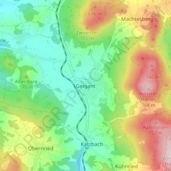
Nombre: Mapa topográfico Geigant, altitud, relieve.
Altitud media: 582 m
Altitud mínima: 468 m
Altitud máxima: 772 m
Otros mapas topográficos
Haga clic en un mapa para ver su topografía, su altitud y su relieve.
Perlhütte
Deutschland > Bayern > Landkreis Cham > Waldmünchen
Perlhütte, Waldmünchen, Landkreis Cham, Bayern, 93449, Deutschland
Altitud media: 583 m
Spielberg
Deutschland > Bayern > Landkreis Cham > Waldmünchen
Spielberg, Waldmünchen, Landkreis Cham, Bayern, 93492, Deutschland
Altitud media: 578 m