
Gracias por apoyar a este sitio ❤️
Haz una donación
Haz una donación
Mapa topográfico Bujumbura
Haga clic en el mapa para ver la altitud.
Gracias por apoyar a este sitio ❤️
Haz una donación
Haz una donación
Bujumbura
Bujumbura has a tropical savanna climate (Köppen: Aw) bordering on hot semi-arid (BSh). There are distinct wet and dry seasons; the wet season being from October to April. Being close to the equator, average temperatures in the city vary little over the year, though they are affected by its altitude. The high temperature is around 29 °C (84 °F) and the low around 19 °C (66 °F).
Gracias por apoyar a este sitio ❤️
Haz una donación
Haz una donación
Acerca de este mapa
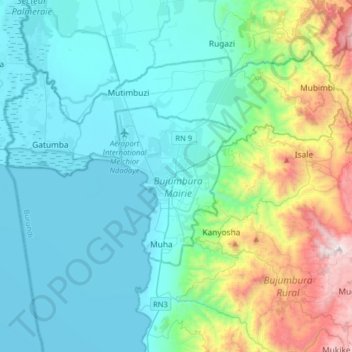
Nombre: Mapa topográfico Bujumbura, altitud, relieve.
Lugar: Bujumbura, Bujumbura Mairie, Burundi (-3.52381 29.20750 -3.20381 29.52750)
Altitud media: 1,106 m
Altitud mínima: 763 m
Altitud máxima: 2,520 m
Gracias por apoyar a este sitio ❤️
Haz una donación
Haz una donación