
Mapa topográfico Rowland CP
Haga clic en el mapa para ver la altitud.
Acerca de este mapa
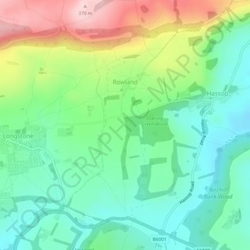
Nombre: Mapa topográfico Rowland CP, altitud, relieve.
Altitud media: 221 m
Altitud mínima: 138 m
Altitud máxima: 383 m
Otros mapas topográficos
Haga clic en un mapa para ver su topografía, su altitud y su relieve.
Cressbrook Dale
United Kingdom > England > Derbyshire > Derbyshire Dales > Litton CP > Litton Mill
Altitud media: 286 m
Hallam Moors
United Kingdom > England > Derbyshire > Derbyshire Dales > Hathersage
Altitud media: 368 m
Slaley
United Kingdom > England > Derbyshire > Derbyshire Dales > Matlock > Bonsall CP
Altitud media: 263 m
Bolehill
United Kingdom > England > Derbyshire > Derbyshire Dales > Wirksworth CP
Altitud media: 220 m
Riber Castle
United Kingdom > England > Derbyshire > Derbyshire Dales > Matlock > Starkholmes
Altitud media: 169 m
Monsal Head
United Kingdom > England > Derbyshire > Derbyshire Dales > Cressbrook > Monsal Head
Altitud media: 231 m
Parsley Hay
United Kingdom > England > Derbyshire > Derbyshire Dales > Parsley Hay
Altitud media: 334 m
Two Dales
United Kingdom > England > Derbyshire > Derbyshire Dales > Darley Dale CP > Darley Hillside
Altitud media: 189 m
Magpie Mine
United Kingdom > England > Derbyshire > Derbyshire Dales > Ashford in the Water CP
Altitud media: 303 m
Catcliff Wood
United Kingdom > England > Derbyshire > Derbyshire Dales > Bakewell CP
Altitud media: 173 m
Taddington Dale
United Kingdom > England > Derbyshire > Derbyshire Dales > Brushfield CP
Altitud media: 281 m
Hathersage Booths
United Kingdom > England > Derbyshire > Derbyshire Dales > Hathersage
Altitud media: 260 m
Stanage Plantation
United Kingdom > England > Derbyshire > Derbyshire Dales > Hathersage
Altitud media: 360 m
Black Rocks
United Kingdom > England > Derbyshire > Derbyshire Dales > Cromford CP
Altitud media: 199 m
Padley Gorge
United Kingdom > England > Derbyshire > Derbyshire Dales > Grindleford
Altitud media: 316 m
Horseshoe Quarry
United Kingdom > England > Derbyshire > Derbyshire Dales > Eyam CP
Altitud media: 293 m
Curbar Edge
United Kingdom > England > Derbyshire > Derbyshire Dales > Calver Sough
Altitud media: 251 m
Stoke Brook
United Kingdom > England > Derbyshire > Derbyshire Dales > Calver Sough
Altitud media: 197 m
Calver Sough
United Kingdom > England > Derbyshire > Derbyshire Dales > Calver Sough
Altitud media: 218 m
Longstone Edge
United Kingdom > England > Derbyshire > Derbyshire Dales > Rowland
Altitud media: 290 m
Longcliffe
United Kingdom > England > Derbyshire > Derbyshire Dales > Brassington CP
Altitud media: 299 m
Lathkill Dale
United Kingdom > England > Derbyshire > Derbyshire Dales > Youlgreave
Altitud media: 269 m
Breamfield
United Kingdom > England > Derbyshire > Derbyshire Dales > Wirksworth CP > Breamfield
Altitud media: 213 m
Coplow Dale
United Kingdom > England > Derbyshire > Derbyshire Dales > Little Hucklow
Altitud media: 333 m
Yarncliff Wood
United Kingdom > England > Derbyshire > Derbyshire Dales > Grindleford
Altitud media: 260 m
Breamfield
United Kingdom > England > Derbyshire > Derbyshire Dales > Wirksworth CP
Altitud media: 213 m
Padley Gorge
United Kingdom > England > Derbyshire > Derbyshire Dales > Grindleford
Altitud media: 316 m
Wirksworth Moor
United Kingdom > England > Derbyshire > Derbyshire Dales > Wirksworth CP
Altitud media: 207 m