
Gracias por apoyar a este sitio ❤️
Haz una donación
Haz una donación
Mapa topográfico Saint-Augustin-de-Desmaures
Haga clic en el mapa para ver la altitud.
Gracias por apoyar a este sitio ❤️
Haz una donación
Haz una donación
Acerca de este mapa
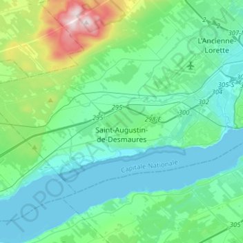
Nombre: Mapa topográfico Saint-Augustin-de-Desmaures, altitud, relieve.
Altitud media: 85 m
Altitud mínima: -3 m
Altitud máxima: 485 m
Gracias por apoyar a este sitio ❤️
Haz una donación
Haz una donación
Otros mapas topográficos
Haga clic en un mapa para ver su topografía, su altitud y su relieve.
Quebec
Canada > Quebec > Urban agglomeration of Québec
Quebec City was built on the north bank of the Saint Lawrence River, where it narrows and meets the mouth of the Saint-Charles River. Old Quebec is located on top and at the foot of Cap-Diamant, which is on the eastern edge of a plateau called the promontory of Quebec (Quebec hill). Because of this topographic…
Altitud media: 100 m
Gracias por apoyar a este sitio ❤️
Haz una donación
Haz una donación