
Mapa topográfico Saint-Jean-de-la-Forêt
Mapa interactivo
Haga clic en el mapa para ver la altitud.
Acerca de este mapa
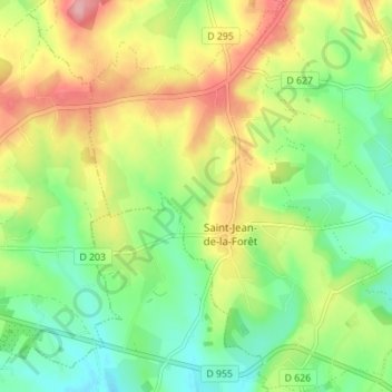
Nombre: Mapa topográfico Saint-Jean-de-la-Forêt, altitud, relieve.
Altitud media: 196 m
Altitud mínima: 144 m
Altitud máxima: 270 m
Otros mapas topográficos
Haga clic en un mapa para ver su topografía, su altitud y su relieve.
Préaux-du-Perche
France > Normandie > Orne > Perche en Nocé
Préaux-du-Perche, Perche en Nocé, Mortagne-au-Perche, Orne, Normandie, France métropolitaine, 61340, France
Altitud media: 147 m
Le Brûlé
France > Normandie > Orne > Perche en Nocé
Le Brûlé, Colonard-Corubert, Perche en Nocé, Mortagne-au-Perche, Orne, Normandie, France métropolitaine, 61340, France
Altitud media: 187 m
Le Rosier
France > Normandie > Orne > Perche en Nocé
Le Rosier, Préaux-du-Perche, Perche en Nocé, Mortagne-au-Perche, Orne, Normandie, France métropolitaine, 61340, France
Altitud media: 158 m
Dancé
France > Normandie > Orne > Perche en Nocé
Dancé, Perche en Nocé, Mortagne-au-Perche, Orne, Normandie, France métropolitaine, 61340, France
Altitud media: 147 m
Saint-Aubin-des-Grois
France > Normandie > Orne > Perche en Nocé
Saint-Aubin-des-Grois, Perche en Nocé, Mortagne-au-Perche, Orne, Normandie, France métropolitaine, 61340, France
Altitud media: 163 m