
Mapa topográfico Waverly
Mapa interactivo
Haga clic en el mapa para ver la altitud.
Acerca de este mapa
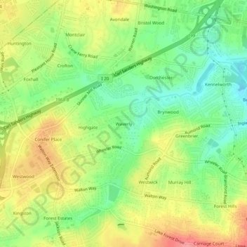
Nombre: Mapa topográfico Waverly, altitud, relieve.
Altitud media: 96 m
Altitud mínima: 54 m
Altitud máxima: 146 m
Otros mapas topográficos
Haga clic en un mapa para ver su topografía, su altitud y su relieve.
Bonair
United States > Georgia > Richmond County > Augusta
Bonair, Augusta, Richmond County, Georgia, 30990, United States
Altitud media: 84 m
Bel Air Heights
United States > Georgia > Richmond County > Augusta
Bel Air Heights, Augusta, Richmond County, Georgia, 30905, United States
Altitud media: 118 m
Fort Gordon
United States > Georgia > Richmond County > Augusta
Fort Gordon, Augusta, Richmond County, Georgia, 30905, United States
Altitud media: 136 m
Berckman Villas
United States > Georgia > Richmond County > Augusta
Berckman Villas, Augusta, Richmond County, Georgia, 30904, United States
Altitud media: 87 m
Nixon
United States > Georgia > Richmond County > Augusta
Nixon, Augusta, Richmond County, Georgia, United States
Altitud media: 45 m
Marion Homes
United States > Georgia > Richmond County > Augusta
Marion Homes, Augusta, Richmond County, Georgia, 30901, United States
Altitud media: 44 m
Soil Erosion Lake Dam
United States > Georgia > Richmond County > Augusta
Soil Erosion Lake Dam, Augusta, Richmond County, Georgia, 30905, United States
Altitud media: 123 m
Kennelworth
United States > Georgia > Richmond County > Augusta
Kennelworth, Augusta, Richmond County, Georgia, 30909, United States
Altitud media: 87 m
Windsor Court
United States > Georgia > Richmond County > Augusta
Windsor Court, Augusta, Richmond County, Georgia, 30904, United States
Altitud media: 66 m
Goshen Plantation
United States > Georgia > Richmond County > Augusta > Goshen Plantation
Goshen Plantation, Augusta, Richmond County, Georgia, United States
Altitud media: 73 m
Ridgewood
United States > Georgia > Richmond County > Augusta > Ridgewood
Ridgewood, Augusta, Richmond County, Georgia, 30909, United States
Altitud media: 103 m