
Gracias por apoyar a este sitio ❤️
Haz una donación
Haz una donación
Mapa topográfico Hoher Hagen
Haga clic en el mapa para ver la altitud.
Gracias por apoyar a este sitio ❤️
Haz una donación
Haz una donación
Acerca de este mapa
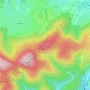
Nombre: Mapa topográfico Hoher Hagen, altitud, relieve.
Altitud media: 500 m
Altitud mínima: 354 m
Altitud máxima: 678 m
Gracias por apoyar a este sitio ❤️
Haz una donación
Haz una donación
Otros mapas topográficos
Haga clic en un mapa para ver su topografía, su altitud y su relieve.
Esenbeck
Deutschland > Nordrhein-Westfalen > Hochsauerlandkreis > Schmallenberg > Obersorpe
Altitud media: 687 m