
Mapa topográfico Telangana
Haga clic en el mapa para ver la altitud.
Acerca de este mapa
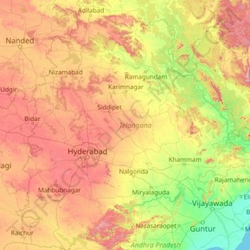
Nombre: Mapa topográfico Telangana, altitud, relieve.
Lugar: Telangana, India (15.83642 77.23659 19.91730 81.32262)
Altitud media: 320 m
Altitud mínima: 0 m
Altitud máxima: 1,262 m
Otros mapas topográficos
Haga clic en un mapa para ver su topografía, su altitud y su relieve.
Junagadh
India > Gujarat > Junagadh City Taluka
Junagadh city is located at 21°31′N 70°28′E / 21.52°N 70.47°E / 21.52; 70.47 at the foot of Mount Girnar, with the Arabian sea to the southwest, Porbandar to the north, and Amreli to the east. It has an average elevation of 107 metres (351 ft).
Altitud media: 163 m
Surat
India > Gujarat > Katargam Taluka > Surat
Surat is a port city situated on the banks of the Tapi river. Damming of the Tapi caused the original port facilities to close; the nearest port is now in the Magadalla and Hazira area of Surat Metropolitan Region.It has famous beach called 'Dumas Beach' located in Hazira. The city is located at 21°10′N…
Altitud media: 11 m
Guwahati
Professor Abani Kumar Bhagawati of Gauhati University stated that since before there were sufficient wetlands to absorb rainwater and channels to carry excess water to the Brahmaputra, the city did not experience floods. However, human interference has disrupted the natural topography, leading to the current…
Altitud media: 113 m
Ayodhya
India > Uttar Pradesh > Faizabad
The earliest of the Buddhist Pali-language texts and the Jain Prakrit-language texts mention a city called Saketa (Sageya or Saeya in Prakrit) as an important city of the Kosala mahajanapada. Topographical indications in both Buddhist and Jain texts suggest that Saketa is the same as the present-day Ayodhya.…
Altitud media: 96 m
Varanasi
India > Uttar Pradesh > Sadar
Varanasi is located at an elevation of 80.71 metres (264.8 ft) in the centre of the Ganges valley of North India, in the Eastern part of the state of Uttar Pradesh, along the left crescent-shaped bank of the Ganges, averaging between 15 metres (50 ft) and 21 metres (70 ft) above the river. The city is the…
Altitud media: 77 m
Vellore
India > Tamil Nadu > Vellore
Vellore is at 12°55′N 79°08′E / 12.92°N 79.13°E / 12.92; 79.13, 220m above sea level. The city has a tropical savanna climate. It is in the Vellore district of the South Indian state, Tamil Nadu, 135 km (84 mi) west of the state capital Chennai and 30 km (19 mi) kms South of its twin city…
Altitud media: 283 m
Navi Mumbai
India > Maharashtra > Thane > Navi Mumbai
Navi Mumbai (Marathi pronunciation: , also known by its former name New Bombay), is a planned city off the west coast of the Indian state of Maharashtra in Konkan division. The city is divided into two parts, North Navi Mumbai and South Navi Mumbai, for the individual development of Panvel Mega City, which…
Altitud media: 30 m
Bhowali
India > Uttarakhand > Nainital
Bhowali (Kumaoni: Bhoāli)[bʱəʋaːli] is a town and municipal board in Nainital District in the state of Uttarakhand, India. It is situated at a distance of 11 km (6.8 mi) from the city of Nainital, the district headquarters; at an average elevation of 1,654 m (5,427 ft) from sea level. It is the seat of…
Altitud media: 1,672 m
Erattupetta
It has an average elevation of 36 metres (118 feet).
Altitud media: 78 m
Ranchi
Ranchi lies at 23°22′N 85°20′E / 23.36°N 85.33°E / 23.36; 85.33 near to the Tropic of Cancer. The city covers an area of 175 km2 (68 sq mi) and its average elevation is 651 m above sea level. Ranchi is located in the southern part of the Chota Nagpur plateau, which is the eastern section of…
Altitud media: 648 m
Mumbai
Mumbai lies at the mouth of the Ulhas River on the western coast of India, in the coastal region known as the Konkan. It sits on Salsette Island (Sashti Island), which it partially shares with the Thane district. Mumbai is bounded by the Arabian Sea to the west. Many parts of the city lie just above sea level,…
Altitud media: 13 m
Visakhapatnam
India > Andhra Pradesh > Visakhapatnam Urban
The city is situated between the Eastern Ghats and the Bay of Bengal. The city coordinates lies between 17.7041 N and 83.2977 E. The city's area is 682 km2. The average elevation is 45 metres. Visakhpatnam is situated in Coastal Andhra Region.
Altitud media: 35 m
Bengaluru
India > Karnataka > Bangalore North
Bengaluru lies in the southeast of the South Indian state of Karnataka in the heart of the Mysore Plateau (a region of the larger Deccan Plateau) at an average elevation of 900 m (2,953 ft). The city covers an area of 741 km2 (286 sq mi). The Bengaluru metropolitan region covers an area of 7,005 km2 (2,705 sq…
Altitud media: 879 m
Yelburga
India > Karnataka > Yelaburga taluku
Yelburga is located at 15°38′N 76°01′E / 15.63°N 76.02°E / 15.63; 76.02. It has an average elevation of 605 metres (1984 feet). It is around 40 km north-west of Koppal.
Altitud media: 600 m
Mahua Dol Earthen Dam Hanumanji Shiv Ganga
India > Madhya Pradesh > Pawai Tahsil > Mahuadol
Altitud media: 506 m
Chikkanayakanahalli
India > Karnataka > Chikkanayakanahalli taluk
Chikkanayakana-halli is located at 13°25′N 76°37′E / 13.42°N 76.62°E / 13.42; 76.62. It has an average elevation of 804 metres (2,638 ft). It is located on National Highway 150A.
Altitud media: 811 m
Mettupalayam
India > Tamil Nadu > Mettupalayam
Mettupalayam is located at 11°18′00″N 76°57′00″E / 11.3000°N 76.9500°E / 11.3000; 76.9500. It has an average elevation of 314 metres (1033 feet). Mettupalayam is situated on the bank of Bhavani River at the foot of the Nilgiri mountains.
Altitud media: 321 m
Shimla
Shimla is on the south-western ranges of the Himalayas at 31°37′N 77°06′E / 31.61°N 77.10°E / 31.61; 77.10. It has an average altitude of 2,206 metres (7,238 ft) above mean sea level and extends along a ridge with seven spurs. The city stretches nearly 9.2 kilometres (5.7 mi) from east to west.
Altitud media: 1,557 m
Cuddalore
India > Tamil Nadu > Cuddalore
Cuddalore is located at 11°45′N 79°45′E / 11.75°N 79.75°E / 11.75; 79.75. It has an average elevation of 6 m (20 ft). The land is completely flat with large deposits of black and alluvial soil inland and coarse sand near the seashore. The sandstone deposits in the town are popular. The…
Altitud media: 8 m
Dhanbad
India > Jharkhand > Dhanbad-Cum-Kenduadih-Cum-Jagata
Dhanbad has an average elevation of 227 m (745 ft). Its geographical length (extending from north to south) is 15 miles (24 km) and the breadth (stretching across east to West) is 10 miles (16 km). It shares its boundaries with West Bengal in the eastern and southern part, Dumka and Giridih in the North and…
Altitud media: 212 m
Mount Abu
India > Rajasthan > Abu Road Tehsil
Mount Abu town, the only hill station in Rajasthan, is at an elevation of 1,220 m (4,003 ft). It has been a popular retreat from the heat of Rajasthan and neighboring Gujarat for centuries.
Altitud media: 914 m
Pimpri-Chinchwad
India > Maharashtra > Haveli
Pimpri-Chinchwad also known as "PCMC", is a city in the Indian state of Maharashtra. The city is about 15 km (9.3 mi) northwest of the historic city of Pune, at an altitude of 590 m (1,940 ft) above sea level. It is the fifth largest city in Maharashtra and the nineteenth largest city in India and the…
Altitud media: 571 m
Dakshina Kannada
The topography of the district is plain up to 30 km (18.64 mi) inside the coast and changes to undulating hilly terrain sharply towards the east in the Western Ghats. Teak, bamboo and rosewood trees are found in the hilly areas towards the east. The Geological Survey of India has identified this district as a…
Altitud media: 109 m
Bhubaneshwar
India > Odisha > Bhubaneswar (M.Corp.)
Bhubaneswar is in Khordha district of Odisha. It is in the eastern coastal plains, along the axis of the Eastern Ghats mountains. The city has an average altitude of 45 m (148 ft) above sea level. It lies southwest of the Mahanadi River that forms the northern boundary of Bhubaneswar metropolitan area, within…
Altitud media: 30 m
Western Ghats
The range starts near south of the Tapti river and runs approximately 1,600 km (990 mi) through the states of Gujarat, Maharashtra, Karnataka, Goa, Kerala and Tamil Nadu ending at Marunthuvazh Malai, Swamithope near the southern tip of India. These hills cover 160,000 km2 (62,000 sq mi) and form the catchment…
Altitud media: 2,225 m
Kapadvanj
India > Gujarat > Kapadvanj Taluka
Kapadvanj is located at 23°01′N 73°04′E / 23.02°N 73.07°E / 23.02; 73.07. It has an average elevation of 69 metres (226 feet).
Altitud media: 77 m
Maharashtra
Maharashtra is the third largest state by area in India. The Western Ghats better known as Sahyadri, are a hilly range running parallel to the coast, at an average elevation of 1,200 metres (4,000 ft). Kalsubai, a peak in the Sahyadris, near Nashik city is the highest elevated point in Maharashtra. To the west…
Altitud media: 478 m
Tirunelveli
India > Tamil Nadu > Palayamkottai
Tirunelveli is located at 8°43′41.82″N 77°41′43.94″E / 8.7282833°N 77.6955389°E / 8.7282833; 77.6955389, and its average elevation is 47 metres (154 ft). It is located at the southernmost tip of the Deccan plateau. The Tamirabarani River divides the city into the Tirunelveli quarter and…
Altitud media: 34 m
Patna
India > Bihar > Patna Rural
Patna is on the southern bank of the river Ganges. The total area of Patna is 250 km2 (97 sq mi). Of this, the municipal area constitutes 109.218 km2 (42.169 sq mi). The suburban area covers 140.782 km2 (54.356 sq mi). It has an average elevation of 53 m (174 ft). A characteristic feature of the geography of…
Altitud media: 51 m
Siliguri
India > West Bengal > Matigara block
Siliguri located at the foothills of the eastern Himalayas at a location of 26°43′N 88°26′E / 26.71°N 88.43°E / 26.71; 88.43. This city is spread over an area of 260 km2 within the Siliguri Corridor, also known as the Chicken's neck. The city is surrounded by dense forests towards north and…
Altitud media: 121 m
Dehradun
India > Uttarakhand > Dehradun
The city of Dehradun mainly lies in Doon Valley and is at a varying height from 410 m (1,350 ft) in Clement Town to above 700 m (2,300 ft) at Malsi which is 15 km (9.3 mi) from the city. However, the average elevation is 450 m (1,480 ft) above sea level. Malsi is the starting point of Lesser Himalayan Range…
Altitud media: 904 m
Bhopal
India > Madhya Pradesh > Huzur Tahsil
Bhopal has an average elevation of 500 metres (1401 ft) and is located in the central part of India, just north of the upper limit of the Vindhya mountain ranges. Located on the Malwa plateau, it is higher than the north Indian plains and the land rises towards the Vindhya Range to the south. The city has…
Altitud media: 498 m
Kolkata
Spread roughly north–south along the east bank of the Hooghly River, Kolkata sits within the lower Ganges Delta of eastern India approximately 75 km (47 mi) west of the international border with Bangladesh; the city's elevation is 1.5–9 m (5–30 ft). Much of the city was originally a wetland that was…
Altitud media: 5 m
Salem
Salem is located at 11°40′N 78°08′E / 11.67°N 78.14°E / 11.67; 78.14, at an average elevation of 278 m (912 ft). The city is surrounded by hills: Nagaramalai on the north, Jarugumalai on the south, Kanjamalai on the west, Godumalai on the east and the Shevaroy Hills on the northeast.…
Altitud media: 418 m
Durgapur
India > West Bengal > Faridpur Durgapur
Durgapur is located at 23°33′N 87°19′E / 23.55°N 87.32°E / 23.55; 87.32. It has an average elevation of 65 metres (213 ft).
Altitud media: 76 m