
Haz una donación
Mapa topográfico Hacıbektaş
Haga clic en el mapa para ver la altitud.
Haz una donación
Hacıbektaş
Hacıbektaş, formerly Karahöyük, is a town and district of Nevşehir Province in the Central Anatolia region of Turkey. According to 2000 census, population of the district is 11,929 of which 5,169 live in the town of Hacıbektaş. Located in Cappadocia, the district covers an area of 697 km2 (269 sq mi), and the average elevation is 1,250 m (4,101 ft), with the highest point being Mt. Kırlangıç at 1,720 m (5,643 ft). The town is named after Haji Bektash Veli, a 13th-century Sufi saint who founded the Bektashi Order.
Haz una donación
Acerca de este mapa
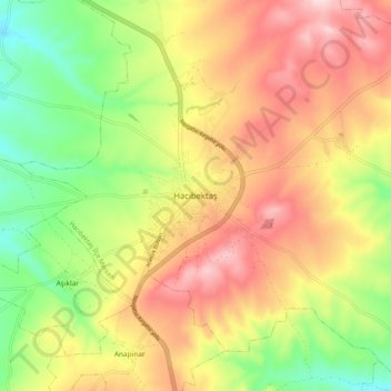
Nombre: Mapa topográfico Hacıbektaş, altitud, relieve.
Lugar: Hacıbektaş, Nevşehir, Central Anatolia Region, 50800, Turkey (38.90288 34.52088 38.98288 34.60088)
Altitud media: 1,269 m
Altitud mínima: 1,120 m
Altitud máxima: 1,419 m
Haz una donación